Forecast Details for Caguas, 025

Recent Locations: Wheeler, OR   Alanson, MI   Caguas, 025  
Overnight: Showers likely, mainly after 3am. Mostly cloudy, with a low around 71. East southeast wind around 5 mph. Chance of precipitation is 60%.
Friday: Showers likely, then showers and possibly a thunderstorm after 9am. High near 85. East wind 6 to 9 mph. Chance of precipitation is 80%. New rainfall amounts between a half and three quarters of an inch possible.
Friday Night: Scattered showers. Mostly cloudy, with a low around 72. Light east southeast wind. Chance of precipitation is 50%. New precipitation amounts between a quarter and half of an inch possible.
Saturday: Scattered showers, mainly after noon. Mostly sunny, with a high near 84. East wind 5 to 10 mph. Chance of precipitation is 40%.
Saturday Night: Scattered showers, mainly before midnight. Partly cloudy, with a low around 71. Light east wind. Chance of precipitation is 30%.
Sunday: Isolated showers. Mostly sunny, with a high near 85. East wind 5 to 9 mph. Chance of precipitation is 20%.
Sunday Night: Partly cloudy, with a low around 71. Light east wind.
Monday: Scattered showers, mainly after noon. Mostly sunny, with a high near 85. East wind 5 to 10 mph. Chance of precipitation is 40%.
Monday Night: Partly cloudy, with a low around 71. Light east wind.
Tuesday: Scattered showers. Mostly sunny, with a high near 86. Chance of precipitation is 30%.
Tuesday Night: Partly cloudy, with a low around 71.
Wednesday: Scattered showers. Partly sunny, with a high near 86. Chance of precipitation is 40%.
Wednesday Night: Partly cloudy, with a low around 71.
Thursday: Scattered showers. Mostly sunny, with a high near 85. Chance of precipitation is 30%.

Want more detail? Get the Complete 7 Day and Night Detailed Forecast!


Weather Topic: What are Wall Clouds?

Home - Education - Cloud Types - Wall Clouds

Wall Clouds Next Topic: Altocumulus Clouds

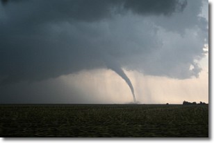
A wall cloud forms underneath the base of a cumulonimbus cloud, and can be a hotbed for deadly tornadoes.

Wall clouds are formed by air flowing into the cumulonimbus clouds, which can result in the wall cloud descending from the base of the cumulonimbus cloud, or rising fractus clouds which join to the base of the storm cloud as the wall cloud takes shape.

Wall clouds can be very large, and in the Northern Hemisphere they generally form at the southern edge of cumulonimbus clouds.

Next Topic: Altocumulus Clouds

Weather Topic: What are Altostratus Clouds?

Home - Education - Cloud Types - Altostratus Clouds

Altostratus Clouds Next Topic: Cirrocumulus Clouds

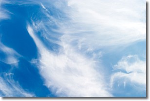
Altostratus clouds form at mid to high-level altitudes (between 2 and 7 km) and are created by a warm, stable air mass which causes water vapor to condense as it rise through the atmosphere. Usually altostratus clouds are featureless sheets characterized by a uniform color.

In some cases, wind punching through the cloud formation may give it a waved appearance, called altostratus undulatus. Altostratus clouds are commonly seen with other cloud formations accompanying them.

Next Topic: Cirrocumulus Clouds

Current conditions powered by WeatherAPI.com