Weather Alerts for California
1. Air Quality Alert for: Calabasas and Agoura Hills; Eastern San Fernando Valley; Eastern San Gabriel Mountains; Eastern Santa Monica Mountains Recreational Area; Interstate 5 Corridor; Los Angeles County Beaches; Los Angeles County Inland Coast including Downtown Los Angeles; Los Angeles County San Gabriel Valley; Malibu Coast; Palos Verdes Hills; Santa Clarita Valley; Santa Susana Mountains; Western San Fernando Valley; Western San Gabriel Mountains and Highway 14 Corridor; Western Santa Monica Mountains Recreational Area
2. Air Quality Alert for: Eastern San Fernando Valley; Eastern Santa Monica Mountains Recreational Area; Los Angeles County Beaches; Los Angeles County Inland Coast including Downtown Los Angeles; Los Angeles County San Gabriel Valley; Malibu Coast; Palos Verdes Hills; Santa Clarita Valley; Santa Susana Mountains; Western San Fernando Valley; Western Santa Monica Mountains Recreational Area
3. Air Quality Alert for: San Bernardino and Riverside County Valleys-The Inland Empire; San Bernardino County Mountains; Santa Ana Mountains and Foothills; San Gorgonio Pass Near Banning; Orange County Coastal; Orange County Inland
4. Air Quality Alert for: San Bernardino and Riverside County Valleys-The Inland Empire; Santa Ana Mountains and Foothills; San Gorgonio Pass Near Banning; Orange County Coastal; Orange County Inland
5. Beach Hazards Statement for: Catalina and Santa Barbara Islands; Ventura County Beaches; Malibu Coast; Los Angeles County Beaches
6. Beach Hazards Statement for: San Diego County Coastal Areas; Orange County Coastal
7. Lake Wind Advisory for: Greater Lake Tahoe Area; Greater Lake Tahoe Area
8. Lake Wind Advisory for: Mono; Greater Reno-Carson City-Minden Area; Western Nevada Basin and Range including Pyramid Lake
9. Red Flag Warning for: Eastern Lassen County; Northern Sierra Front - Carson City/Douglas/Storey/Southern Washoe/Eastern Lyon/Far Southern Lassen Counties; Southern Sierra Front - Alpine/Northern Mono/Southern Lyon/Western Mineral Counties; West Humboldt Basin - Pershing County; Lahontan Basin - Churchill and Eastern Mineral Counties; Northern Washoe County
10. Red Flag Warning for: Modoc County Except for the Surprise Valley
Want more detail? Get the Complete 7 Day and Night Detailed Forecast!
Current U.S. National Radar--Current
The Current National Weather Radar is shown below with a UTC Time (subtract 5 hours from UTC to get Eastern Time).

National Weather Forecast--Current
The Current National Weather Forecast and National Weather Map are shown below.

National Weather Forecast for Tomorrow
Tomorrow National Weather Forecast and Tomorrow National Weather Map are show below.

North America Water Vapor (Moisture)
This map shows recent moisture content over North America. Bright and colored areas show high moisture (ie, clouds); brown indicates very little moisture present; black indicates no moisture.

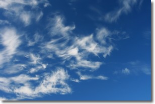
Weather Topic: What are Cirrostratus Clouds?
Home - Education - Cloud Types - Cirrostratus Clouds
 Next Topic: Cirrus Clouds
Cirrostratus clouds are high, thin clouds that form above
20,000 feet and are made mostly of ice crystals. They sometimes look like giant
feathers, horse tails, or curls of hair in the sky.
These clouds are pushed by the jet stream and can move at high speeds reaching
100 mph.
What do they indicate?
They indicate that a precipitation is likely within 24 hours.
Next Topic: Cirrus Clouds
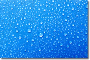
Weather Topic: What is Condensation?
Home - Education - Precipitation - Condensation
 Next Topic: Contrails
Condensation is the process which creates clouds, and therefore
it is a crucial process in the water cycle.
Condensation is the change of matter from a state of gas into a state of liquid,
and it happens because water molecules release heat into the atmosphere and
become organized into a more closely packed structure, what we might see as
water droplets.
Water is always present in the air around us as a vapor, but it's too small for
us to see. When water undergoes the process of condensation it becomes organized
into visible water droplets. You've probably seen condensation happen before on the
surface of a cold drink!
Next Topic: Contrails
Current conditions powered by WeatherAPI.com


