Weather Alert in Indiana
Flood Warning issued March 7 at 12:56PM EST until March 8 at 11:25PM EDT by NWS Indianapolis IN
AREAS AFFECTED: Bartholomew, IN; Johnson, IN; Shelby, IN
DESCRIPTION: ...The Flood Warning continues for the following rivers in Indiana... East Fork White River near Bedford, Rivervale, Williams, and Shoals. Driftwood River near Edinburgh. ...The Flood Warning is extended for the following rivers in Indiana... East Fork White River at Columbus and Seymour. .Total rainfall amounts of 3 to over 5 inches of rain across much of central and southern Indiana is bringing widespread moderate flooding across the East Fork White basin and their tributaries. Additional rainfall earlier today, and next week could lengthen the amount of time area rivers remain in flood or bring additional rises next week. * WHAT...Minor flooding is occurring and minor flooding is forecast. * WHERE...Driftwood River near Edinburgh. * WHEN...Until late tomorrow evening. * IMPACTS...At 14.0 feet, Extensive flooding along Big Blue River in Edinburgh area. In Johnson County CR 650S between CR 700E and CR 800E flooded. Water approaching or on CR 700E near CR 775S. Irwin Park in Edinburgh extensively flooded. Water affecting one residence in Shelby County at CR 900W and CR 1000S. * ADDITIONAL DETAILS... - At 11:30 AM EST Saturday the stage was 13.6 feet. - Recent Activity...The maximum river stage in the 24 hours ending at 11:30 AM EST Saturday was 14.7 feet. - Forecast...The river is expected to fall below flood stage late tomorrow morning and continue falling and remain below flood stage. - Flood stage is 11.0 feet. - http://www.weather.gov/safety/flood
INSTRUCTION: Flooding is occurring or is imminent. Most flood related deaths occur in automobiles. Do not attempt to cross water covered bridges, dips, or low water crossings. Never try to cross a flowing stream, even a small one, on foot. To escape rising water find another route over higher ground. Caution is urged when walking near riverbanks. Additional information is available at www.weather.gov/ind. The next statement should be issued this evening by around 800 PM EST.
Want more detail? Get the Complete 7 Day and Night Detailed Forecast!
Current U.S. National Radar--Current
The Current National Weather Radar is shown below with a UTC Time (subtract 5 hours from UTC to get Eastern Time).

National Weather Forecast--Current
The Current National Weather Forecast and National Weather Map are shown below.

National Weather Forecast for Tomorrow
Tomorrow National Weather Forecast and Tomorrow National Weather Map are show below.

North America Water Vapor (Moisture)
This map shows recent moisture content over North America. Bright and colored areas show high moisture (ie, clouds); brown indicates very little moisture present; black indicates no moisture.

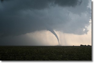
Weather Topic: What are Wall Clouds?
Home - Education - Cloud Types - Wall Clouds
 Next Topic: Altocumulus Clouds
A wall cloud forms underneath the base of a cumulonimbus cloud,
and can be a hotbed for deadly tornadoes.
Wall clouds are formed by air flowing into the cumulonimbus clouds, which can
result in the wall cloud descending from the base of the cumulonimbus cloud, or
rising fractus clouds which join to the base of the storm cloud as the wall cloud
takes shape.
Wall clouds can be very large, and in the Northern Hemisphere they generally
form at the southern edge of cumulonimbus clouds.
Next Topic: Altocumulus Clouds
Weather Topic: What are Altostratus Clouds?
Home - Education - Cloud Types - Altostratus Clouds
 Next Topic: Cirrocumulus Clouds
Altostratus clouds form at mid to high-level altitudes
(between 2 and 7 km) and are created by a warm, stable air mass which causes
water vapor
to condense as it rise through the atmosphere. Usually altostratus clouds are
featureless sheets characterized by a uniform color.
In some cases, wind punching through the cloud formation may give it a waved
appearance, called altostratus undulatus. Altostratus clouds
are commonly seen with other cloud formations accompanying them.
Next Topic: Cirrocumulus Clouds
Current conditions powered by WeatherAPI.com


