Weather Alert in Minnesota
Heat Advisory issued July 3 at 2:13PM CDT until July 4 at 8:00PM CDT by NWS Duluth MN
AREAS AFFECTED: Koochiching; North St. Louis; Northern Cook/Northern Lake; North Itasca; Central St. Louis; North Cass; South Itasca; South Cass; Crow Wing; Northern Aitkin; South Aitkin; Carlton/South St. Louis; Pine; Douglas; Bayfield; Ashland; Iron; Burnett; Washburn; Sawyer; Price
DESCRIPTION: * WHAT...Heat index values of 94 to 100 degrees expected. * WHERE...In Minnesota, Crow Wing, Aitkin, Pine, Koochiching, Cass, Itasca, Carlton, St. Louis, and Northern Cook and Lake Counties. In Wisconsin, Price, Ashland, Bayfield, Burnett, Douglas, Iron, Sawyer, and Washburn Counties. This includes the Tribal Lands of the Lac Courte Oreilles Reservation, the St. Croix Band in Burnett County, the Red Cliff Band, the Bad River Reservation, the Fond du Lac Band, the northwestern area of the Lac du Flambeau Band, the Mille Lacs Band, Hinckley, Lena Lake, East Lake and, Big Sandy Lake areas and the Bois Forte Band, Deer Creek, Nett Lake and, Lake Vermilion areas. Other locations including the Apostle Islands National Lakeshore, Madeline Island and Voyageurs National Park. The entire Boundary Waters is also included. * WHEN...From 11 AM to 8 PM CDT Friday. * IMPACTS...Hot temperatures and high humidity may cause heat illnesses.
INSTRUCTION: Drink plenty of fluids, stay in an air-conditioned room if possible, stay out of the sun, and check up on relatives and neighbors.
Want more detail? Get the Complete 7 Day and Night Detailed Forecast!
Current U.S. National Radar--Current
The Current National Weather Radar is shown below with a UTC Time (subtract 5 hours from UTC to get Eastern Time).

National Weather Forecast--Current
The Current National Weather Forecast and National Weather Map are shown below.

National Weather Forecast for Tomorrow
Tomorrow National Weather Forecast and Tomorrow National Weather Map are show below.

North America Water Vapor (Moisture)
This map shows recent moisture content over North America. Bright and colored areas show high moisture (ie, clouds); brown indicates very little moisture present; black indicates no moisture.

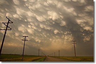
Weather Topic: What are Mammatus Clouds?
Home - Education - Cloud Types - Mammatus Clouds
 Next Topic: Nimbostratus Clouds
A mammatus cloud is a cloud with a unique feature which resembles
a web of pouches hanging along the base of the cloud.
In the United States, mammatus clouds tend to form in the warmer months, commonly
in the Midwest and eastern regions.
While they usually form at the bottom of a cumulonimbis cloud, they can also form
under altostratus, altocumulus, stratocumulus, and cirrus clouds. Mammatus clouds
warn that severe weather is close.
Next Topic: Nimbostratus Clouds
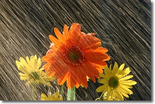
Weather Topic: What is Precipitation?
Home - Education - Precipitation - Precipitation
 Next Topic: Rain
Precipitation can refer to many different forms of water that
may fall from clouds. Precipitation occurs after a cloud has become saturated to
the point where its water particles are more dense than the air below the cloud.
In most cases, precipitation will reach the ground, but it is not uncommon for
precipitation to evaporate before it reaches the earth's surface.
When precipitation evaporates before it contacts the ground it is called Virga.
Graupel, hail, sleet, rain, drizzle, and snow are forms of precipitation, but fog
and mist are not considered precipitation because the water vapor which
constitutes them isn't dense enough to fall to the ground.
Next Topic: Rain
Current conditions powered by WeatherAPI.com


