Weather Alert in Pennsylvania
Severe Thunderstorm Warning issued March 7 at 5:26PM EST until March 7 at 6:15PM EST by NWS State College PA
AREAS AFFECTED: Cambria, PA; Clearfield, PA
DESCRIPTION: SVRCTP The National Weather Service in State College PA has issued a * Severe Thunderstorm Warning for... Northeastern Cambria County in central Pennsylvania... Clearfield County in central Pennsylvania... * Until 615 PM EST. * At 526 PM EST, severe thunderstorms were located along a line extending from Parker Dam State Park to 12 miles north of Hastings to near Northern Cambria, moving northeast at 50 mph. HAZARD...60 mph wind gusts. SOURCE...Radar indicated. IMPACT...Expect damage to roofs, siding, and trees. * Locations impacted include... DuBois, Clearfield, Sandy, Northern Cambria, Woodland, Curwensville, Patton, Hyde, Hastings, Plymptonville, Rockton, and Carrolltown. For those driving on Interstate 80, this includes areas between the Dubois Route 255 and Snow Shoe exits, specifically from mile markers 101 to 138.
INSTRUCTION: Stay inside a well built structure and keep away from windows. A Tornado Watch remains in effect until 800 PM EST for central and north central Pennsylvania.
Want more detail? Get the Complete 7 Day and Night Detailed Forecast!
Current U.S. National Radar--Current
The Current National Weather Radar is shown below with a UTC Time (subtract 5 hours from UTC to get Eastern Time).

National Weather Forecast--Current
The Current National Weather Forecast and National Weather Map are shown below.

National Weather Forecast for Tomorrow
Tomorrow National Weather Forecast and Tomorrow National Weather Map are show below.

North America Water Vapor (Moisture)
This map shows recent moisture content over North America. Bright and colored areas show high moisture (ie, clouds); brown indicates very little moisture present; black indicates no moisture.

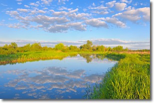
Weather Topic: What are Stratocumulus Clouds?
Home - Education - Cloud Types - Stratocumulus Clouds
 Next Topic: Stratus Clouds
Stratocumulus clouds are similar to altocumulus clouds in their
fluffy appearance, but have a slightly darker shade due to their additional mass.
A good way to distinguish the two cloud types is to hold your hand out and measure
the size of an individual cloud; if it is the size of your thumb it is generally
an altocumulus cloud, if it is the size of your hand it is generally a
stratocumulus cloud.
It is uncommon for stratocumulus clouds to produce precipitation, but if they do
it is usually a light rain or snow.
Next Topic: Stratus Clouds
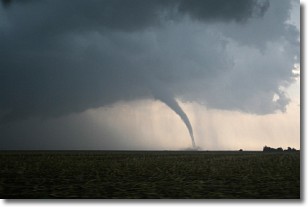
Weather Topic: What are Wall Clouds?
Home - Education - Cloud Types - Wall Clouds
 Next Topic: Altocumulus Clouds
A wall cloud forms underneath the base of a cumulonimbus cloud,
and can be a hotbed for deadly tornadoes.
Wall clouds are formed by air flowing into the cumulonimbus clouds, which can
result in the wall cloud descending from the base of the cumulonimbus cloud, or
rising fractus clouds which join to the base of the storm cloud as the wall cloud
takes shape.
Wall clouds can be very large, and in the Northern Hemisphere they generally
form at the southern edge of cumulonimbus clouds.
Next Topic: Altocumulus Clouds
Current conditions powered by WeatherAPI.com


