Weather Alert in Alaska
Winter Storm Watch issued February 26 at 4:06PM AKST until March 1 at 6:00AM AKST by NWS Juneau AK
AREAS AFFECTED: Glacier Bay; Eastern Chichagof Island; Cape Fairweather to Lisianski Strait
DESCRIPTION: ...POTENTIAL OVERRUNNING SNOW EVENT FOR SUNDAY INTO MONDAY... .Cold Arctic air is expected to move into the panhandle for the end of the week into next week. With the cold air in place, moisture associated with a low over the Gulf into the Bering Sea is expected to move over the area. With the warmer nature of the moisture and colder air at the surface, snow is expected to fall across the Panhandle. Current guidance suggests that the most significant snow will be over the parts of the Central Panhandle that holds onto the cold air longer. There is the potential that this overrunning snow event lasts into the middle to end of next week. This will depend on how long the cold air persists through the Inner Channels. Meanwhile snow showers continue into the Thursday night for parts of the panhandle. * WHAT...For the Winter Weather Advisory, snow. Additional snow accumulations of up to two inches. For the Winter Storm Watch, heavy snow possible. Total snow accumulations of 6 to 12 inches possible. * WHERE...Glacier Bay, Eastern Chichagof Island and Cape Fairweather to Lisianski Strait. * WHEN...For the Winter Weather Advisory, until 9 PM AKST this evening. For the Winter Storm Watch, from Saturday morning through late Saturday night. * IMPACTS...Travel could be very difficult. * ADDITIONAL DETAILS...For the winter weather advisory, snow showers continue with visibility less then a mile at times possible. For the winter storm watch, Snow is expected to start Saturday morning and could potentially last into the start of next week with cold Arctic air in place and warm, moisture rich air moving over.
INSTRUCTION: Slow down and use caution while traveling. Monitor the latest forecasts for updates on this situation. People are urged to prepare their property before the onset of winter weather. For the latest road conditions, where available, call 5 1 1 or visit 511.alaska.gov.
Want more detail? Get the Complete 7 Day and Night Detailed Forecast!
Current U.S. National Radar--Current
The Current National Weather Radar is shown below with a UTC Time (subtract 5 hours from UTC to get Eastern Time).

National Weather Forecast--Current
The Current National Weather Forecast and National Weather Map are shown below.

National Weather Forecast for Tomorrow
Tomorrow National Weather Forecast and Tomorrow National Weather Map are show below.

North America Water Vapor (Moisture)
This map shows recent moisture content over North America. Bright and colored areas show high moisture (ie, clouds); brown indicates very little moisture present; black indicates no moisture.

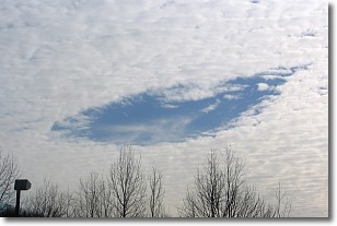
Weather Topic: What are Hole Punch Clouds?
Home - Education - Cloud Types - Hole Punch Clouds
 Next Topic: Mammatus Clouds
A hole punch cloud is an unusual occurrence when a disk-shaped
hole appears in a cirrostratus, cirrocumulus, or altocumulus cloud.
When part of the cloud forms ice crystals, water droplets in the surrounding area
of the cloud evaporate. The effect of this process produces a large elliptical
gap in the cloud. The hole punch cloud formation is rare, but it is not specific
to any geographic area.
Other names which have been used to describe this phenomena include fallstreak hole,
skypunch, and cloud hole.
Next Topic: Mammatus Clouds
Weather Topic: What are Nimbostratus Clouds?
Home - Education - Cloud Types - Nimbostratus Clouds
 Next Topic: Precipitation
A nimbostratus cloud is similar to a stratus cloud in its formless,
smooth appearance. However, a nimbostratus cloud is darker than a stratus cloud,
because it is thicker.
Unlike a stratus cloud, a nimbostratus cloud typically brings with it the threat
of moderate to heavy precipitation. In some cases, the precipitation may evaporate
before reaching the ground, a phenomenon known as virga.
Next Topic: Precipitation
Current conditions powered by WeatherAPI.com


