Weather Alert in Nevada
Hydrologic Outlook issued April 3 at 2:01AM PDT by NWS Elko NV
AREAS AFFECTED: Elko, NV; Humboldt, NV
DESCRIPTION: ESFLKN Near record warmth is expected in portions of Northern and Central Nevada during the middle to latter part of next week. This will accelerate the process of snowmelt and enhance runoff into area creeks and rivers. Creeks and rivers that are susceptible to rapid water level rises will be most impacted. Waterways affected include, but are not limited to Martin Creek in Humboldt County, the Owyhee River in Elko County, the Bruneau River in Elko County, and Salmon Falls Creek in Elko County. Salmon Falls Creek is expected to reach action stage (9.0 feet) late next week. Action stage is the level which some type of mitigation is needed in preparation for possible minor flooding. At this time, Salmon Falls Creek is not anticipated to reach minor flood stage (10.0 feet). Residents and outdoor enthusiasts are urged to exercise caution when walking near rapidly flowing, cold water. Hypothermia can occur quickly if someone were to fall into cold, swift water.
INSTRUCTION: N/A
Want more detail? Get the Complete 7 Day and Night Detailed Forecast!
Current U.S. National Radar--Current
The Current National Weather Radar is shown below with a UTC Time (subtract 5 hours from UTC to get Eastern Time).

National Weather Forecast--Current
The Current National Weather Forecast and National Weather Map are shown below.

National Weather Forecast for Tomorrow
Tomorrow National Weather Forecast and Tomorrow National Weather Map are show below.

North America Water Vapor (Moisture)
This map shows recent moisture content over North America. Bright and colored areas show high moisture (ie, clouds); brown indicates very little moisture present; black indicates no moisture.

Weather Topic: What is Hail?
Home - Education - Precipitation - Hail
 Next Topic: Hole Punch Clouds
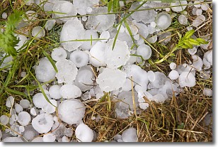
Hail is a form of precipitation which is recognized by large solid balls or
clumps of ice. Hail is created by thunderstorm clouds with strong updrafts of wind.
As the hailstones remain in the updraft, ice is deposited onto them until their
weight becomes heavy enough for them to fall to the earth's surface.
Hail storms can cause significant damage to crops, aircrafts, and man-made structures,
despite the fact that the duration is usually less than ten minutes.
Next Topic: Hole Punch Clouds
Weather Topic: What are Mammatus Clouds?
Home - Education - Cloud Types - Mammatus Clouds
 Next Topic: Nimbostratus Clouds
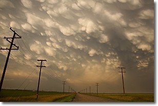
A mammatus cloud is a cloud with a unique feature which resembles
a web of pouches hanging along the base of the cloud.
In the United States, mammatus clouds tend to form in the warmer months, commonly
in the Midwest and eastern regions.
While they usually form at the bottom of a cumulonimbis cloud, they can also form
under altostratus, altocumulus, stratocumulus, and cirrus clouds. Mammatus clouds
warn that severe weather is close.
Next Topic: Nimbostratus Clouds
Current conditions powered by WeatherAPI.com


