Weather Alert in Texas
Flood Warning issued July 3 at 1:20PM CDT until July 4 at 1:25PM CDT by NWS Midland/Odessa TX
AREAS AFFECTED: Brewster, TX
DESCRIPTION: ...The National Weather Service in Midland/Odessa TX has issued a Flood Warning for the following rivers in Texas... Rio Grande at Rio Grande near Castolon, Texas affecting Brewster County. For the Rio Grande...including Rio Grande above Rio Conchos near Presidio, Texas, Rio Grande at Presidio Vehicle Bridge, Rio Grande below Rio Conchos near Presidio, Texas, Rio Grande near Castolon, Texas, Rio Grande at Johnson Ranch near Castolon, Texas, Rio Grande at Rio Grande Village, BBNP, Texas, Rio Grande near Dryden, Texas, Terlingua Creek near Terlingua, Texas...Major flooding is forecast. * WHAT...Minor flooding is occurring and moderate flooding is forecast. * WHERE...Rio Grande at Rio Grande near Castolon, Texas. * WHEN...From this afternoon to early tomorrow afternoon. * IMPACTS...At 13.0 feet (4.0 meters), the river reaches bankfull, and no significant damage is expected. At 15.0 feet (4.6 meters), the river reaches minor flood stage, and lowland flooding begins. The river begins to flood the road between Santa Elena Canyon and Cottonwood Campground in Big Bend National Park. The river begins to flood the parking lot at Santa Elena Canyon, and cut off the nature trail into the canyon. Campers in Cottonwood Campground need to prepare for possible evacuations. At 19.0 feet (5.8 meters), the river reaches moderate flood stage, and begins flooding Cottonwood Campground. The river inundates the restrooms upstream at Santa Elena Canyon parking lot. The river begins to close all area roads. * ADDITIONAL DETAILS... - At 12:15 PM CDT Thursday the stage was 18.4 feet (5.6 meters). - Bankfull stage is 13.0 feet (4.0 meters). - Recent Activity...The maximum river stage in the 24 hours ending at 12:15 PM CDT Thursday was 18.4 feet (5.6 meters). - Forecast...The river is expected to rise to a crest of 19.5 feet (5.9 meters) late this afternoon. It will then fall below flood stage early tomorrow afternoon. - Flood stage is 15.0 feet (4.6 meters). - Flood History...No available flood history. - http://www.weather.gov/safety/flood
INSTRUCTION: Turn around, don't drown when encountering flooded roads. Most flood deaths occur in vehicles. Caution is urged when walking near riverbanks. Please report observed flooding to local emergency services or law enforcement and request they pass this information to the National Weather Service when you can do so safely. Additional information is available at www.weather.gov. The next statement will be issued late tonight at 130 AM CDT.
Want more detail? Get the Complete 7 Day and Night Detailed Forecast!
Current U.S. National Radar--Current
The Current National Weather Radar is shown below with a UTC Time (subtract 5 hours from UTC to get Eastern Time).

National Weather Forecast--Current
The Current National Weather Forecast and National Weather Map are shown below.

National Weather Forecast for Tomorrow
Tomorrow National Weather Forecast and Tomorrow National Weather Map are show below.

North America Water Vapor (Moisture)
This map shows recent moisture content over North America. Bright and colored areas show high moisture (ie, clouds); brown indicates very little moisture present; black indicates no moisture.

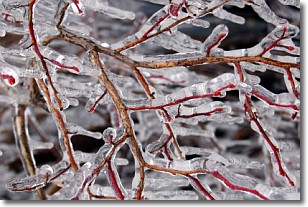
Weather Topic: What is Freezing Rain?
Home - Education - Precipitation - Freezing Rain
 Next Topic: Graupel
Freezing rain is a condition where precipitation which has fallen in the form of
water droplets reaches temperatures which are below freezing and freezes upon
coming into contact
with surface objects. The result of this precipitation is a glaze of ice which
can be damaging to plants and man-made structures. A severe onset of freezing
rain which results in a very thick glaze of ice is known as an ice storm.
Next Topic: Graupel
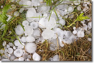
Weather Topic: What is Hail?
Home - Education - Precipitation - Hail
 Next Topic: Hole Punch Clouds
Hail is a form of precipitation which is recognized by large solid balls or
clumps of ice. Hail is created by thunderstorm clouds with strong updrafts of wind.
As the hailstones remain in the updraft, ice is deposited onto them until their
weight becomes heavy enough for them to fall to the earth's surface.
Hail storms can cause significant damage to crops, aircrafts, and man-made structures,
despite the fact that the duration is usually less than ten minutes.
Next Topic: Hole Punch Clouds
Current conditions powered by WeatherAPI.com


