Weather Alert in Colorado
Avalanche Advisory issued February 27 at 5:49PM MST by NWS Denver CO
AREAS AFFECTED: Gore and Elk Mountains/Central Mountain Valleys; South and East Jackson/Larimer/North and Northeast Grand/Northwest Boulder Counties Above 9000 Feet; South and Southeast Grand/West Central and Southwest Boulder/Gilpin/Clear Creek/Summit/North and West Park Counties Above 9000 Feet; Western Mosquito Range/East Lake County Above 11000 Ft; Eastern Sawatch Mountains above 11000 Ft; Western Chaffee County Between 9000 and 11000 Ft
DESCRIPTION: SABCO THE FOLLOWING MESSAGE IS TRANSMITTED AT THE REQUEST OF THE COLORADO AVALANCHE INFORMATION CENTER. ...A SPECIAL AVALANCHE ADVISORY IN EFFECT FROM FRIDAY EVENING THROUGH SUNDAY... *WHAT...It is very easy for people to trigger large and deadly avalanches through the weekend. *WHERE...The Never Summer Mountains south over Berthoud Pass and Loveland Pass into Summit County, the Gore Range, and the northern Sawatch. *WHEN...Dangerous avalanche conditions exist through Sunday. *IMPACTS...Very large and dangerous avalanches will be easy to trigger. *PRECAUTION/PREPAREDNESS ACTIONS...These are the most dangerous conditions we have experienced all season. You can trigger a very large avalanche from a distance or from below. You may get no warning signs before you trigger a deadly avalanche. Careful planning and conservative terrain selection are essential for safe travel in backcountry avalanche terrain. Avoid travel on or under slopes steeper than 30 degrees. You can find more detailed information at colorado.gov/avalanche Pritchett
INSTRUCTION: N/A
Want more detail? Get the Complete 7 Day and Night Detailed Forecast!
Current U.S. National Radar--Current
The Current National Weather Radar is shown below with a UTC Time (subtract 5 hours from UTC to get Eastern Time).

National Weather Forecast--Current
The Current National Weather Forecast and National Weather Map are shown below.

National Weather Forecast for Tomorrow
Tomorrow National Weather Forecast and Tomorrow National Weather Map are show below.

North America Water Vapor (Moisture)
This map shows recent moisture content over North America. Bright and colored areas show high moisture (ie, clouds); brown indicates very little moisture present; black indicates no moisture.

Weather Topic: What are Hole Punch Clouds?
Home - Education - Cloud Types - Hole Punch Clouds
 Next Topic: Mammatus Clouds
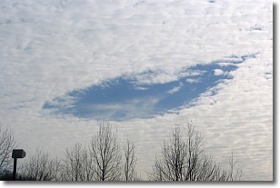
A hole punch cloud is an unusual occurrence when a disk-shaped
hole appears in a cirrostratus, cirrocumulus, or altocumulus cloud.
When part of the cloud forms ice crystals, water droplets in the surrounding area
of the cloud evaporate. The effect of this process produces a large elliptical
gap in the cloud. The hole punch cloud formation is rare, but it is not specific
to any geographic area.
Other names which have been used to describe this phenomena include fallstreak hole,
skypunch, and cloud hole.
Next Topic: Mammatus Clouds
Weather Topic: What are Nimbostratus Clouds?
Home - Education - Cloud Types - Nimbostratus Clouds
 Next Topic: Precipitation
A nimbostratus cloud is similar to a stratus cloud in its formless,
smooth appearance. However, a nimbostratus cloud is darker than a stratus cloud,
because it is thicker.
Unlike a stratus cloud, a nimbostratus cloud typically brings with it the threat
of moderate to heavy precipitation. In some cases, the precipitation may evaporate
before reaching the ground, a phenomenon known as virga.
Next Topic: Precipitation
Current conditions powered by WeatherAPI.com


