Weather Alert in Illinois
Flood Warning issued April 3 at 12:20PM CDT by NWS Paducah KY
AREAS AFFECTED: Gallatin, IL; Wayne, IL; White, IL
DESCRIPTION: ...The Flood Warning is extended for the following rivers in Illinois... Little Wabash River at Carmi affecting Gallatin, Wayne and White Counties. ...The Flood Warning continues for the following rivers in Illinois... Skillet Fork River at Wayne City affecting Wayne and White Counties. .A multi-day heavy rain is headed toward the region lasting through Saturday. Three days of rainfall is incorporated into the forecast but it still does not include the entire event. The Skillet Fork and Little Wabash Rivers have started to rise and increases in crest forecasts can be expected. Now is the time to prepare for major flooding. * WHAT...Major flooding is forecast. * WHERE...Little Wabash River at Carmi. * WHEN...From Friday afternoon until further notice. * IMPACTS...At 35.5 feet, Businesses just downstream of IL Route 14 and Route 1 in Carmi flood. * ADDITIONAL DETAILS... - At 11:30 AM CDT Thursday the stage was 21.9 feet. - Forecast...The river is expected to rise above flood stage tomorrow afternoon and continue rising to a crest of 34.6 feet Sunday morning. It will then rise to 35.5 feet Wednesday evening. Additional rises are possible thereafter. - Flood stage is 27.0 feet.
INSTRUCTION: Motorists should not attempt to drive around barricades or drive cars through flooded areas. Caution is urged when walking near riverbanks. Turn around, don't drown when encountering flooded roads. Most flood deaths occur in vehicles. Be especially cautious at night when it is harder to recognize the dangers of flooding. Additional information is available at www.weather.gov.
Want more detail? Get the Complete 7 Day and Night Detailed Forecast!
Current U.S. National Radar--Current
The Current National Weather Radar is shown below with a UTC Time (subtract 5 hours from UTC to get Eastern Time).

National Weather Forecast--Current
The Current National Weather Forecast and National Weather Map are shown below.

National Weather Forecast for Tomorrow
Tomorrow National Weather Forecast and Tomorrow National Weather Map are show below.

North America Water Vapor (Moisture)
This map shows recent moisture content over North America. Bright and colored areas show high moisture (ie, clouds); brown indicates very little moisture present; black indicates no moisture.

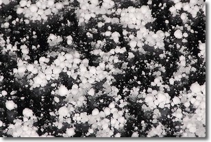
Weather Topic: What is Graupel?
Home - Education - Precipitation - Graupel
 Next Topic: Hail
Graupel is a form of precipitation that is created by atmospheric conditions
which cause supercooled water droplets to contact snow crystals and freeze to
their surface.
Sometimes known as soft hail or snow pellets, graupel is delicate and easily
destroyed by touch. Whereas hail usually falls during severe weather, graupel
doesn't require such conditions to form, and can form in mild precipitation
similar to situations which produce snowfall.
Next Topic: Hail
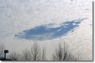
Weather Topic: What are Hole Punch Clouds?
Home - Education - Cloud Types - Hole Punch Clouds
 Next Topic: Mammatus Clouds
A hole punch cloud is an unusual occurrence when a disk-shaped
hole appears in a cirrostratus, cirrocumulus, or altocumulus cloud.
When part of the cloud forms ice crystals, water droplets in the surrounding area
of the cloud evaporate. The effect of this process produces a large elliptical
gap in the cloud. The hole punch cloud formation is rare, but it is not specific
to any geographic area.
Other names which have been used to describe this phenomena include fallstreak hole,
skypunch, and cloud hole.
Next Topic: Mammatus Clouds
Current conditions powered by WeatherAPI.com


