Weather Alert in Indiana
Winter Weather Advisory issued March 2 at 7:20AM EST until March 2 at 11:00AM EST by NWS Wilmington OH
AREAS AFFECTED: Ripley; Dearborn; Ohio; Switzerland; Carroll; Gallatin; Boone; Kenton; Campbell; Owen; Grant; Pendleton; Bracken; Robertson; Mason; Lewis; Hamilton; Clermont; Brown; Adams; Scioto
DESCRIPTION: * WHAT...Mixed precipitation expected. Total snow and sleet accumulations up to one inch, with ice accumulations of up to a tenth of an inch. * WHERE...Portions of southeast Indiana, northeast and northern Kentucky, and south central and southwest Ohio. * WHEN...Until 11 AM EST this morning. * IMPACTS...Roads, and especially bridges and overpasses, will likely become slick and hazardous. Plan on slippery road conditions. The hazardous conditions could impact the Monday morning commute.
INSTRUCTION: Slow down and use caution while traveling. In Indiana, visit 511in.org or call 1-800-261-7623 for the latest road information. In Kentucky, visit goky.ky.gov for the latest road information. In Ohio, visit ohgo.com for the latest road information. Be prepared for slippery roads. Slow down and use caution while driving. If you are going outside, watch your first few steps taken on stairs, sidewalks, and driveways. These surfaces could be icy and slippery, increasing your risk of a fall and injury.
Want more detail? Get the Complete 7 Day and Night Detailed Forecast!
Current U.S. National Radar--Current
The Current National Weather Radar is shown below with a UTC Time (subtract 5 hours from UTC to get Eastern Time).

National Weather Forecast--Current
The Current National Weather Forecast and National Weather Map are shown below.

National Weather Forecast for Tomorrow
Tomorrow National Weather Forecast and Tomorrow National Weather Map are show below.

North America Water Vapor (Moisture)
This map shows recent moisture content over North America. Bright and colored areas show high moisture (ie, clouds); brown indicates very little moisture present; black indicates no moisture.

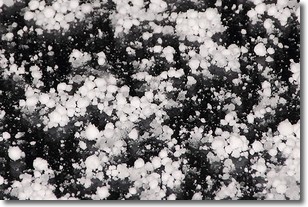
Weather Topic: What is Graupel?
Home - Education - Precipitation - Graupel
 Next Topic: Hail
Graupel is a form of precipitation that is created by atmospheric conditions
which cause supercooled water droplets to contact snow crystals and freeze to
their surface.
Sometimes known as soft hail or snow pellets, graupel is delicate and easily
destroyed by touch. Whereas hail usually falls during severe weather, graupel
doesn't require such conditions to form, and can form in mild precipitation
similar to situations which produce snowfall.
Next Topic: Hail
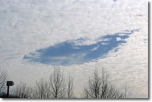
Weather Topic: What are Hole Punch Clouds?
Home - Education - Cloud Types - Hole Punch Clouds
 Next Topic: Mammatus Clouds
A hole punch cloud is an unusual occurrence when a disk-shaped
hole appears in a cirrostratus, cirrocumulus, or altocumulus cloud.
When part of the cloud forms ice crystals, water droplets in the surrounding area
of the cloud evaporate. The effect of this process produces a large elliptical
gap in the cloud. The hole punch cloud formation is rare, but it is not specific
to any geographic area.
Other names which have been used to describe this phenomena include fallstreak hole,
skypunch, and cloud hole.
Next Topic: Mammatus Clouds
Current conditions powered by WeatherAPI.com


