Weather Alert in Missouri
Flood Warning issued March 6 at 6:22PM CST until March 9 at 4:16PM CDT by NWS St Louis MO
AREAS AFFECTED: Jefferson, MO
DESCRIPTION: ...The Flood Warning is extended for the following rivers in Missouri... Big River at Byrnesville. River forecasts are based on observed precipitation and forecast precipitation for the next 48 hours. * WHAT...Moderate flooding is occurring and moderate flooding is forecast. * WHERE...Big River at Byrnesville. * WHEN...Until Monday afternoon. * IMPACTS...At 22.4 feet, At this level, Twin Rivers Bridge Road must be closed. * ADDITIONAL DETAILS... - At 5:45 PM CST Friday the stage was 20.5 feet. - Recent Activity...The maximum river stage in the 24 hours ending at 5:45 PM CST Friday was 20.5 feet. - Forecast...The river is expected to rise to a crest of 22.5 feet early tomorrow afternoon. It will then fall below flood stage Sunday afternoon. - Flood stage is 16.0 feet.
INSTRUCTION: Turn around, don't drown when encountering flooded roads. Most flood deaths occur in vehicles. This product, along with additional weather and stream information, is available at https://water.noaa.gov/wfo/lsx
Want more detail? Get the Complete 7 Day and Night Detailed Forecast!
Current U.S. National Radar--Current
The Current National Weather Radar is shown below with a UTC Time (subtract 5 hours from UTC to get Eastern Time).

National Weather Forecast--Current
The Current National Weather Forecast and National Weather Map are shown below.

National Weather Forecast for Tomorrow
Tomorrow National Weather Forecast and Tomorrow National Weather Map are show below.

North America Water Vapor (Moisture)
This map shows recent moisture content over North America. Bright and colored areas show high moisture (ie, clouds); brown indicates very little moisture present; black indicates no moisture.

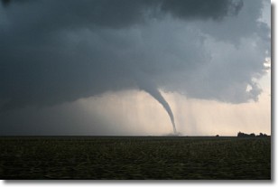
Weather Topic: What are Wall Clouds?
Home - Education - Cloud Types - Wall Clouds
 Next Topic: Altocumulus Clouds
A wall cloud forms underneath the base of a cumulonimbus cloud,
and can be a hotbed for deadly tornadoes.
Wall clouds are formed by air flowing into the cumulonimbus clouds, which can
result in the wall cloud descending from the base of the cumulonimbus cloud, or
rising fractus clouds which join to the base of the storm cloud as the wall cloud
takes shape.
Wall clouds can be very large, and in the Northern Hemisphere they generally
form at the southern edge of cumulonimbus clouds.
Next Topic: Altocumulus Clouds
Weather Topic: What are Altostratus Clouds?
Home - Education - Cloud Types - Altostratus Clouds
 Next Topic: Cirrocumulus Clouds
Altostratus clouds form at mid to high-level altitudes
(between 2 and 7 km) and are created by a warm, stable air mass which causes
water vapor
to condense as it rise through the atmosphere. Usually altostratus clouds are
featureless sheets characterized by a uniform color.
In some cases, wind punching through the cloud formation may give it a waved
appearance, called altostratus undulatus. Altostratus clouds
are commonly seen with other cloud formations accompanying them.
Next Topic: Cirrocumulus Clouds
Current conditions powered by WeatherAPI.com


