Weather Alert in Georgia
Special Weather Statement issued March 2 at 6:33PM EST by NWS Charleston SC
AREAS AFFECTED: Coastal Bryan; Coastal Chatham; Coastal Liberty; Inland McIntosh; Coastal McIntosh
DESCRIPTION: Areas of dense sea fog are impacting the Georgia coast this evening. The fog is mainly impacting the coastal waters and inland waterways such as the Intracoastal Waterway and the various inlets, rivers and sounds down the coast, including a few of the barrier islands such as Sapelo Island and Tybee Island. The fog is expected to gradually expand inland across the coastal counties of Georgia this evening and may become dense at times with visibilities dropping to 1/4 mile or less. A Dense Fog Advisory may be needed.
INSTRUCTION: If driving, slow down and leave extra distance ahead of you in case a sudden stop is needed.
Want more detail? Get the Complete 7 Day and Night Detailed Forecast!
Current U.S. National Radar--Current
The Current National Weather Radar is shown below with a UTC Time (subtract 5 hours from UTC to get Eastern Time).

National Weather Forecast--Current
The Current National Weather Forecast and National Weather Map are shown below.

National Weather Forecast for Tomorrow
Tomorrow National Weather Forecast and Tomorrow National Weather Map are show below.

North America Water Vapor (Moisture)
This map shows recent moisture content over North America. Bright and colored areas show high moisture (ie, clouds); brown indicates very little moisture present; black indicates no moisture.

Weather Topic: What is Hail?
Home - Education - Precipitation - Hail
 Next Topic: Hole Punch Clouds
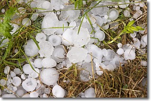
Hail is a form of precipitation which is recognized by large solid balls or
clumps of ice. Hail is created by thunderstorm clouds with strong updrafts of wind.
As the hailstones remain in the updraft, ice is deposited onto them until their
weight becomes heavy enough for them to fall to the earth's surface.
Hail storms can cause significant damage to crops, aircrafts, and man-made structures,
despite the fact that the duration is usually less than ten minutes.
Next Topic: Hole Punch Clouds
Weather Topic: What are Mammatus Clouds?
Home - Education - Cloud Types - Mammatus Clouds
 Next Topic: Nimbostratus Clouds
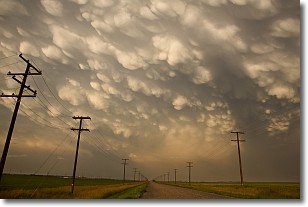
A mammatus cloud is a cloud with a unique feature which resembles
a web of pouches hanging along the base of the cloud.
In the United States, mammatus clouds tend to form in the warmer months, commonly
in the Midwest and eastern regions.
While they usually form at the bottom of a cumulonimbis cloud, they can also form
under altostratus, altocumulus, stratocumulus, and cirrus clouds. Mammatus clouds
warn that severe weather is close.
Next Topic: Nimbostratus Clouds
Current conditions powered by WeatherAPI.com


