Weather Alert in California
Red Flag Warning issued July 3 at 4:35AM PDT until July 4 at 12:00AM PDT by NWS Reno NV
AREAS AFFECTED: Eastern Lassen County; Northern Sierra Front - Carson City/Douglas/Storey/Southern Washoe/Eastern Lyon/Far Southern Lassen Counties; Southern Sierra Front - Alpine/Northern Mono/Southern Lyon/Western Mineral Counties; West Humboldt Basin - Pershing County; Lahontan Basin - Churchill and Eastern Mineral Counties; Northern Washoe County
DESCRIPTION: * Affected Area...Fire Weather Zone 278 Eastern Lassen County, Fire Weather Zone 420 Northern Sierra Front including Carson City, Douglas, Storey, Southern Washoe, Western Lyon, and Far Southern Lassen Counties, Fire Weather Zone 421 Southern Sierra Front including Alpine, Northern Mono, Southern Lyon, and Western Mineral Counties, Fire Weather Zone 423 West Humboldt Basin in Pershing County, Fire Weather Zone 429 Lahontan Basin including Churchill and Eastern Mineral Counties and Fire Weather Zone 458 Northern Washoe County. * Winds...West to southwest winds 15 to 25 mph with gusts to 35 mph with wind prone areas gusting up to 45 mph. * Humidity...Relative humidity will range 10 to 15 percent Thursday afternoon into the evening. * Duration...There is potential for 3 to 6 hours of gusty winds along with low relative humidity values. * Impacts...The combination of gusty winds and low humidity can cause fire to rapidly grow in size and intensity before first responders can contain them.
INSTRUCTION: Avoid outdoor activities that can cause a spark near dry vegetation, such as yard work, target shooting, or campfires. Follow local fire restrictions. Check weather.gov/reno for updates and livingwithfire.info for preparedness tips.
Want more detail? Get the Complete 7 Day and Night Detailed Forecast!
Current U.S. National Radar--Current
The Current National Weather Radar is shown below with a UTC Time (subtract 5 hours from UTC to get Eastern Time).

National Weather Forecast--Current
The Current National Weather Forecast and National Weather Map are shown below.

National Weather Forecast for Tomorrow
Tomorrow National Weather Forecast and Tomorrow National Weather Map are show below.

North America Water Vapor (Moisture)
This map shows recent moisture content over North America. Bright and colored areas show high moisture (ie, clouds); brown indicates very little moisture present; black indicates no moisture.

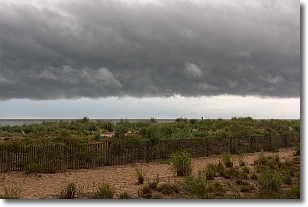
Weather Topic: What are Shelf Clouds?
Home - Education - Cloud Types - Shelf Clouds
 Next Topic: Sleet
A shelf cloud is similar to a wall cloud, but forms at the front
of a storm cloud, instead of at the rear, where wall clouds form.
A shelf cloud is caused by a series of events set into motion by the advancing
storm; first, cool air settles along the ground where precipitation has just fallen.
As the cool air is brought in, the warmer air is displaced, and rises above it,
because it is less dense. When the warmer air reaches the bottom of the storm cloud,
it begins to cool again, and the resulting condensation is a visible shelf cloud.
Next Topic: Sleet
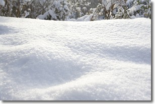
Weather Topic: What is Snow?
Home - Education - Precipitation - Snow
 Next Topic: Stratocumulus Clouds
Snow is precipitation taking the form of ice crystals. Each ice crystal, or snowflake,
has unique characteristics, but all of them grow in a hexagonal structure.
Snowfall can last for sustained periods of time and result in significant buildup
of snow on the ground.
On the earth's surface, snow starts out light and powdery, but as it begins to melt
it tends to become more granular, producing small bits of ice which have the consistency of
sand. After several cycles of melting and freezing, snow can become very dense
and ice-like, commonly known as snow pack.
Next Topic: Stratocumulus Clouds
Current conditions powered by WeatherAPI.com


