Weather Alert in California
Air Quality Alert issued July 2 at 2:12PM PDT by NWS San Diego CA
AREAS AFFECTED: San Bernardino and Riverside County Valleys-The Inland Empire; Santa Ana Mountains and Foothills; San Gorgonio Pass Near Banning; Orange County Coastal; Orange County Inland
DESCRIPTION: * WHAT...The South Coast AQMD has issued an air quality alert due to harmful levels of fine particle pollution. * WHERE...Orange County and the Inland Empire. Levels of particle pollution can vary by time and location depending on emissions and local weather conditions. * WHEN...5 PM July 4th through 11:59 PM July 5th. * IMPACTS...Particle pollution can get deep into the lungs and cause serious health problems such as heart attacks, bronchitis, asthma attacks, and difficulty breathing. Everyone can be affected, but sensitive groups such as people with lung or heart disease, older adults, people who are pregnant, children, and those who spend a lot of time outdoors are at greater risk.
INSTRUCTION: To protect your health, check air quality levels and act as needed: * When Air Quality Index (AQI) levels are "Unhealthy for Sensitive Groups" (orange), sensitive groups as specified above should limit extended or intense outdoor activity. * When AQI is "Unhealthy" (red), everyone may experience health impacts. Sensitive groups should avoid extended time outdoors. * When AQI is "Very Unhealthy" (purple), sensitive groups should avoid all outdoor physical activity. Everyone else should avoid extended or intense outdoor activity. * When AQI is "Hazardous" (maroon), everyone should avoid all outdoor physical activity. * ADDITIONAL DETAILS... To help keep indoor air clean when air quality is poor: * Keep windows and doors closed * Run your air conditioner and/or an air purifier * Do not use whole house fans or swamp coolers that bring in outside air if you have other methods to stay cool * Avoid other sources of pollution such as fireplaces, candles, incense, grilling, and gasoline-powered lawn and garden equipment To view current and forecasted air quality levels, visit the South Coast Air Quality Management District website at aqmd.gov or download the mobile app at www.aqmd.gov/mobileapp. Additional details for this air quality alert may be available at www.aqmd.gov/advisory. For the latest air quality forecasts and information, visit the website at aqmd.gov.
Want more detail? Get the Complete 7 Day and Night Detailed Forecast!
Current U.S. National Radar--Current
The Current National Weather Radar is shown below with a UTC Time (subtract 5 hours from UTC to get Eastern Time).

National Weather Forecast--Current
The Current National Weather Forecast and National Weather Map are shown below.

National Weather Forecast for Tomorrow
Tomorrow National Weather Forecast and Tomorrow National Weather Map are show below.

North America Water Vapor (Moisture)
This map shows recent moisture content over North America. Bright and colored areas show high moisture (ie, clouds); brown indicates very little moisture present; black indicates no moisture.

Weather Topic: What is Sleet?
Home - Education - Precipitation - Sleet
 Next Topic: Snow
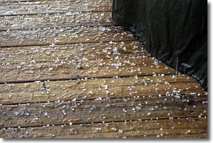
Sleet is a form of precipitation in which small ice pellets are the primary
components. These ice pellets are smaller and more translucent than hailstones,
and harder than graupel. Sleet is caused by specific atmospheric conditions and
therefore typically doesn't last for extended periods of time.
The condition which leads to sleet formation requires a warmer body of air to be
wedged in between two sub-freezing bodies of air. When snow falls through a warmer
layer of air it melts, and as it falls through the next sub-freezing body of air
it freezes again, forming ice pellets known as sleet. In some cases, water
droplets don't have time to freeze before reaching the surface and the result is
freezing rain.
Next Topic: Snow
Weather Topic: What are Stratocumulus Clouds?
Home - Education - Cloud Types - Stratocumulus Clouds
 Next Topic: Stratus Clouds
Stratocumulus clouds are similar to altocumulus clouds in their
fluffy appearance, but have a slightly darker shade due to their additional mass.
A good way to distinguish the two cloud types is to hold your hand out and measure
the size of an individual cloud; if it is the size of your thumb it is generally
an altocumulus cloud, if it is the size of your hand it is generally a
stratocumulus cloud.
It is uncommon for stratocumulus clouds to produce precipitation, but if they do
it is usually a light rain or snow.
Next Topic: Stratus Clouds
Current conditions powered by WeatherAPI.com


