Weather Alert in Colorado
Red Flag Warning issued March 5 at 12:20AM MST until March 5 at 7:00PM MST by NWS Pueblo CO
AREAS AFFECTED: Fremont County Including Canon City/Howard/Texas Creek; San Luis Valley Including Alamosa/Del Norte/Fort Garland/Saguache; Southern Front Range Including Sangre De Cristo Mountains/Wet Mountains/La Veta Pass; Northern El Paso County Including Monument and Black Forest; Southern El Paso County Including Fort Carson and Colorado Springs; Pueblo County Including Pueblo; Huerfano County Including Walsenburg; Western Las Animas County Including Trinidad and Thatcher; Crowley County Including Ordway; Otero County Including La Junta and Western Comanche Grasslands; Eastern Las Animas County Including Pinon Canyon; Kiowa County Including Eads; Bent County Including Las Animas; Prowers County Including Lamar; Baca County Including Springfield and Eastern Comanche Grasslands
DESCRIPTION: * AFFECTED AREA...Fire Weather Zones 222, 224, 225, 226, 227, 228, 229, 230, 231, 232, 233, 234, 235, 236 and 237. * WINDS...Southwest 15 to 30 mph with gusts up to 45 mph. The strongest winds will be in and near the mountains. * RELATIVE HUMIDITY...As low as 8 percent. * IMPACTS...Elevated fire danger is expected. Fires will catch and spread rapidly and erratically.
INSTRUCTION: A Red Flag Warning means that critical fire weather conditions are either occurring now, or will shortly. A combination of strong winds, low relative humidity, and warm temperatures can contribute to extreme fire behavior.
Want more detail? Get the Complete 7 Day and Night Detailed Forecast!
Current U.S. National Radar--Current
The Current National Weather Radar is shown below with a UTC Time (subtract 5 hours from UTC to get Eastern Time).

National Weather Forecast--Current
The Current National Weather Forecast and National Weather Map are shown below.

National Weather Forecast for Tomorrow
Tomorrow National Weather Forecast and Tomorrow National Weather Map are show below.

North America Water Vapor (Moisture)
This map shows recent moisture content over North America. Bright and colored areas show high moisture (ie, clouds); brown indicates very little moisture present; black indicates no moisture.

Weather Topic: What is Drizzle?
Home - Education - Precipitation - Drizzle
 Next Topic: Evaporation
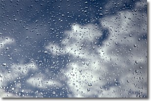
Drizzle is precipitation in the form of water droplets which are
smaller than raindrops.
Drizzle is characterized by fine, gently falling droplets and typically does not
impact human habitation in a negative way. The exception to this is freezing drizzle,
a condition where drizzle freezes immediately upon reaching earth's surface.
Freezing drizzle is still less dangerous than freezing rain, but can
potentially result in hazardous road conditions.
Next Topic: Evaporation
Weather Topic: What is Fog?
Home - Education - Cloud Types - Fog
 Next Topic: Fractus Clouds
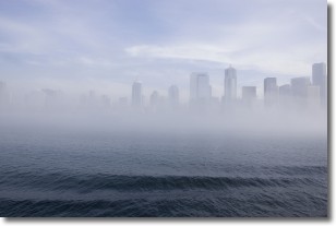
Fog is technically a type of stratus cloud, which lies along the
ground and obscures visibility.
It is usually created when humidity in the air condenses into tiny water droplets.
Because of this, some places are more prone to foggy weather, such as regions
close to a body of water.
Fog is similar to mist; both are the appearance of water droplets suspended in
the air, but fog is the term applied to the condition when visibility is less than 1 km.
Next Topic: Fractus Clouds
Current conditions powered by WeatherAPI.com


