Weather Alert in Maryland
Special Weather Statement issued February 27 at 4:08AM EST by NWS Baltimore MD/Washington DC
AREAS AFFECTED: Washington; Frederick; Carroll; Northern Baltimore; Cecil; Southern Baltimore; Northwest Montgomery; Central and Southeast Montgomery; Northwest Howard; Central and Southeast Howard; Northwest Harford; Southeast Harford; Augusta; Rockingham; Shenandoah; Frederick; Page; Warren; Clarke; Albemarle; Greene; Madison; Rappahannock; Orange; Culpeper; Fairfax; Northern Fauquier; Southern Fauquier; Eastern Highland; Western Loudoun; Eastern Loudoun; Northwest Prince William; Central and Southeast Prince William/Manassas/Manassas Park; Hampshire; Berkeley; Jefferson; Hardy; Eastern Grant; Eastern Pendleton
DESCRIPTION: Patchy fog has developed across much of the region, especially in valleys and other low lying areas. While visibilities may be variable, some fog is locally dense with visibility less than one quarter mile. Temperatures in many of these locations have fallen into the upper 20s and lower 30s, which could result in freezing fog. Any residual moisture from Thursday's rain could also result in icy spots. Expect the fog to gradually erode by mid morning. If driving early this morning, be prepared for rapidly changing conditions. Slow down, increase following distance, and use low beam headlights when encountering dense fog. Any road surfaces which appear wet may actually be icy.
INSTRUCTION: N/A
Want more detail? Get the Complete 7 Day and Night Detailed Forecast!
Current U.S. National Radar--Current
The Current National Weather Radar is shown below with a UTC Time (subtract 5 hours from UTC to get Eastern Time).

National Weather Forecast--Current
The Current National Weather Forecast and National Weather Map are shown below.

National Weather Forecast for Tomorrow
Tomorrow National Weather Forecast and Tomorrow National Weather Map are show below.

North America Water Vapor (Moisture)
This map shows recent moisture content over North America. Bright and colored areas show high moisture (ie, clouds); brown indicates very little moisture present; black indicates no moisture.

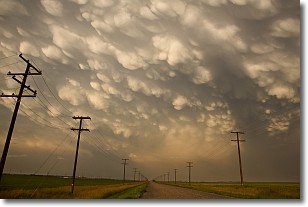
Weather Topic: What are Mammatus Clouds?
Home - Education - Cloud Types - Mammatus Clouds
 Next Topic: Nimbostratus Clouds
A mammatus cloud is a cloud with a unique feature which resembles
a web of pouches hanging along the base of the cloud.
In the United States, mammatus clouds tend to form in the warmer months, commonly
in the Midwest and eastern regions.
While they usually form at the bottom of a cumulonimbis cloud, they can also form
under altostratus, altocumulus, stratocumulus, and cirrus clouds. Mammatus clouds
warn that severe weather is close.
Next Topic: Nimbostratus Clouds
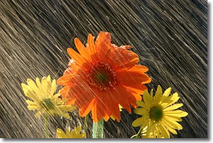
Weather Topic: What is Precipitation?
Home - Education - Precipitation - Precipitation
 Next Topic: Rain
Precipitation can refer to many different forms of water that
may fall from clouds. Precipitation occurs after a cloud has become saturated to
the point where its water particles are more dense than the air below the cloud.
In most cases, precipitation will reach the ground, but it is not uncommon for
precipitation to evaporate before it reaches the earth's surface.
When precipitation evaporates before it contacts the ground it is called Virga.
Graupel, hail, sleet, rain, drizzle, and snow are forms of precipitation, but fog
and mist are not considered precipitation because the water vapor which
constitutes them isn't dense enough to fall to the ground.
Next Topic: Rain
Current conditions powered by WeatherAPI.com


