Weather Alert in Illinois
Flood Warning issued April 4 at 12:16PM EDT by NWS Indianapolis IN
AREAS AFFECTED: Lawrence, IL; Wabash, IL; Knox, IN
DESCRIPTION: ...The National Weather Service in Indianapolis IN has issued a Flood Warning for the following rivers in Indiana...Illinois... Wabash River at Vincennes. .Significant flooding is expected to develop along the Wabash River due to prior rains and additional rounds of heavy rainfall through Sunday. Additional rainfall of 1.5 to three inches in the upper and middle Wabash and three to five inches in the lower Wabash is expected through Sunday. The crest on the Wabash should be in Lafayette late Sunday night to Monday morning and points downstream thereafter. * WHAT...Moderate flooding is forecast. * WHERE...Wabash River at Vincennes. * WHEN...From Saturday evening until further notice. * IMPACTS...At 22.0 feet, Almost all unprotected areas flood. River cabins are surrounded by high water. Oil fields in lowland areas are inaccessible by land vehicles. Most local river roads flood. * ADDITIONAL DETAILS... - At 11:45 AM EDT Friday /10:45 AM CDT Friday/ the stage was 10.8 feet. - Forecast...The river will rise above flood stage tomorrow evening to 18.8 feet Sunday evening and rise to 22.0 feet Saturday, April 12. - Flood stage is 16.0 feet. - http://www.weather.gov/safety/flood
INSTRUCTION: Turn around, don't drown when encountering flooded roads. Most flood deaths occur in vehicles. Additional information is available at www.weather.gov/ind. The next statement should be issued late tonight by around 330 AM EDT /230 AM CDT/.
Want more detail? Get the Complete 7 Day and Night Detailed Forecast!
Current U.S. National Radar--Current
The Current National Weather Radar is shown below with a UTC Time (subtract 5 hours from UTC to get Eastern Time).

National Weather Forecast--Current
The Current National Weather Forecast and National Weather Map are shown below.

National Weather Forecast for Tomorrow
Tomorrow National Weather Forecast and Tomorrow National Weather Map are show below.

North America Water Vapor (Moisture)
This map shows recent moisture content over North America. Bright and colored areas show high moisture (ie, clouds); brown indicates very little moisture present; black indicates no moisture.

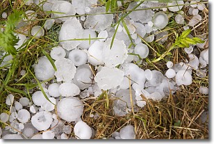
Weather Topic: What is Hail?
Home - Education - Precipitation - Hail
 Next Topic: Hole Punch Clouds
Hail is a form of precipitation which is recognized by large solid balls or
clumps of ice. Hail is created by thunderstorm clouds with strong updrafts of wind.
As the hailstones remain in the updraft, ice is deposited onto them until their
weight becomes heavy enough for them to fall to the earth's surface.
Hail storms can cause significant damage to crops, aircrafts, and man-made structures,
despite the fact that the duration is usually less than ten minutes.
Next Topic: Hole Punch Clouds
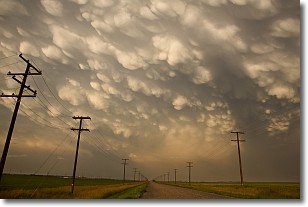
Weather Topic: What are Mammatus Clouds?
Home - Education - Cloud Types - Mammatus Clouds
 Next Topic: Nimbostratus Clouds
A mammatus cloud is a cloud with a unique feature which resembles
a web of pouches hanging along the base of the cloud.
In the United States, mammatus clouds tend to form in the warmer months, commonly
in the Midwest and eastern regions.
While they usually form at the bottom of a cumulonimbis cloud, they can also form
under altostratus, altocumulus, stratocumulus, and cirrus clouds. Mammatus clouds
warn that severe weather is close.
Next Topic: Nimbostratus Clouds
Current conditions powered by WeatherAPI.com


