Weather Alert in Texas
Flash Flood Warning issued July 3 at 3:53PM CDT until July 3 at 7:00PM CDT by NWS Midland/Odessa TX
AREAS AFFECTED: Brewster, TX; Presidio, TX
DESCRIPTION: FFWMAF The National Weather Service in Midland/Odessa has extended the * Flash Flood Warning for... Brewster County in southwestern Texas... Southeastern Presidio County in southwestern Texas... * Until 700 PM CDT. * At 353 PM CDT, Emergency management reported evacuations of campgrounds in Big Bend National Park along the Rio Grande River due to flooding from recent heavy rainfall across the warned area. Between 2 and 4 inches of rain have fallen. Runoff due to heavy rain is expected to continue and flash flooding is ongoing. HAZARD...Life threatening flash flooding. Thunderstorms producing flash flooding. SOURCE...Emergency management reported. IMPACT...Life threatening flash flooding of creeks and streams, urban areas, highways, streets and underpasses. * Some locations that will experience flash flooding include... Panther Junction, Lajitas, Big Bend Ranch State Park, Persimmon Gap, Study Butte, Terlingua, Chisos Basin, Big Bend National Park, Chinati Mountains, Adobes, Terlingua Ranch Airport, Terlingua Ranch Lodge, Santiago Peak, Barton Warnock Environmental Educational Center, Casa Piedra, Redford, Shafter and Presidio Lely International Airport.
INSTRUCTION: Turn around, don't drown when encountering flooded roads. Most flood deaths occur in vehicles. Move to higher ground now. Act quickly to protect your life. Be aware of your surroundings and do not drive on flooded roads. Flooding is occurring or is imminent. It is important to know where you are relative to streams, rivers, or creeks which can become killers in heavy rains. Campers and hikers should avoid streams or creeks.
Want more detail? Get the Complete 7 Day and Night Detailed Forecast!
Current U.S. National Radar--Current
The Current National Weather Radar is shown below with a UTC Time (subtract 5 hours from UTC to get Eastern Time).

National Weather Forecast--Current
The Current National Weather Forecast and National Weather Map are shown below.

National Weather Forecast for Tomorrow
Tomorrow National Weather Forecast and Tomorrow National Weather Map are show below.

North America Water Vapor (Moisture)
This map shows recent moisture content over North America. Bright and colored areas show high moisture (ie, clouds); brown indicates very little moisture present; black indicates no moisture.

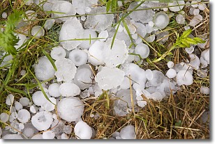
Weather Topic: What is Hail?
Home - Education - Precipitation - Hail
 Next Topic: Hole Punch Clouds
Hail is a form of precipitation which is recognized by large solid balls or
clumps of ice. Hail is created by thunderstorm clouds with strong updrafts of wind.
As the hailstones remain in the updraft, ice is deposited onto them until their
weight becomes heavy enough for them to fall to the earth's surface.
Hail storms can cause significant damage to crops, aircrafts, and man-made structures,
despite the fact that the duration is usually less than ten minutes.
Next Topic: Hole Punch Clouds
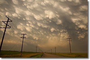
Weather Topic: What are Mammatus Clouds?
Home - Education - Cloud Types - Mammatus Clouds
 Next Topic: Nimbostratus Clouds
A mammatus cloud is a cloud with a unique feature which resembles
a web of pouches hanging along the base of the cloud.
In the United States, mammatus clouds tend to form in the warmer months, commonly
in the Midwest and eastern regions.
While they usually form at the bottom of a cumulonimbis cloud, they can also form
under altostratus, altocumulus, stratocumulus, and cirrus clouds. Mammatus clouds
warn that severe weather is close.
Next Topic: Nimbostratus Clouds
Current conditions powered by WeatherAPI.com


