Weather Alert in Virginia
Winter Weather Advisory issued March 2 at 2:26AM EST until March 3 at 7:00AM EST by NWS Baltimore MD/Washington DC
AREAS AFFECTED: Western Highland; Eastern Highland; Western Grant; Eastern Grant; Western Pendleton; Eastern Pendleton
DESCRIPTION: * WHAT...Mixed precipitation expected. Total snow accumulations of 1 to 3 inches and ice accumulations up to two tenths of an inch. The highest amounts will be along the ridges. * WHERE...Portions of western Virginia and eastern West Virginia. * WHEN...From 10 AM this morning to 7 AM EST Tuesday. * IMPACTS...Plan on slippery road conditions. The hazardous conditions could impact the Monday evening and Tuesday morning commutes. * ADDITIONAL DETAILS...A period of snow is expected from late this morning into this afternoon. There may some breaks during the late afternoon and early evening before a wintry mix of snow, sleet, and then primarily freezing rain affects the area tonight. Precipitation will gradually change to plain rain and taper off Tuesday morning.
INSTRUCTION: Slow down and use caution while traveling. The latest road conditions for the state you are calling from can be obtained by calling 5 1 1.
Want more detail? Get the Complete 7 Day and Night Detailed Forecast!
Current U.S. National Radar--Current
The Current National Weather Radar is shown below with a UTC Time (subtract 5 hours from UTC to get Eastern Time).

National Weather Forecast--Current
The Current National Weather Forecast and National Weather Map are shown below.

National Weather Forecast for Tomorrow
Tomorrow National Weather Forecast and Tomorrow National Weather Map are show below.

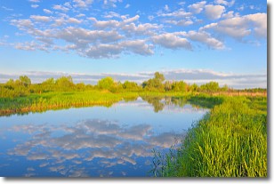
North America Water Vapor (Moisture)
This map shows recent moisture content over North America. Bright and colored areas show high moisture (ie, clouds); brown indicates very little moisture present; black indicates no moisture.

Weather Topic: What are Stratocumulus Clouds?
Home - Education - Cloud Types - Stratocumulus Clouds
 Next Topic: Stratus Clouds
Stratocumulus clouds are similar to altocumulus clouds in their
fluffy appearance, but have a slightly darker shade due to their additional mass.
A good way to distinguish the two cloud types is to hold your hand out and measure
the size of an individual cloud; if it is the size of your thumb it is generally
an altocumulus cloud, if it is the size of your hand it is generally a
stratocumulus cloud.
It is uncommon for stratocumulus clouds to produce precipitation, but if they do
it is usually a light rain or snow.
Next Topic: Stratus Clouds
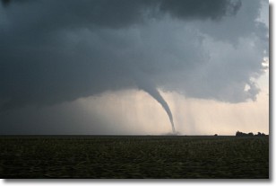
Weather Topic: What are Wall Clouds?
Home - Education - Cloud Types - Wall Clouds
 Next Topic: Altocumulus Clouds
A wall cloud forms underneath the base of a cumulonimbus cloud,
and can be a hotbed for deadly tornadoes.
Wall clouds are formed by air flowing into the cumulonimbus clouds, which can
result in the wall cloud descending from the base of the cumulonimbus cloud, or
rising fractus clouds which join to the base of the storm cloud as the wall cloud
takes shape.
Wall clouds can be very large, and in the Northern Hemisphere they generally
form at the southern edge of cumulonimbus clouds.
Next Topic: Altocumulus Clouds
Current conditions powered by WeatherAPI.com


