Weather Alert in Georgia
Flood Watch issued August 3 at 7:41PM EDT until August 4 at 8:00PM EDT by NWS Peachtree City GA
AREAS AFFECTED: Dade; Walker; Catoosa; Whitfield; Murray; Gilmer; Chattooga; Gordon; Pickens; Dawson; Floyd; Bartow; Cherokee; Forsyth; Polk; Paulding; Cobb; North Fulton; Gwinnett; Haralson; Carroll; Douglas; South Fulton; DeKalb; Rockdale; Walton; Newton; Morgan; Heard; Coweta; Fayette; Clayton; Spalding; Henry; Butts; Jasper; Putnam; Troup; Meriwether; Pike; Upson; Lamar; Monroe; Jones; Baldwin; Harris; Talbot; Taylor; Crawford; Bibb; Twiggs; Wilkinson; Muscogee; Chattahoochee; Marion; Schley; Macon; Peach; Houston; Bleckley; Laurens; Stewart; Webster; Sumter; Dooly; Crisp; Pulaski; Wilcox; Dodge; Telfair; Wheeler
DESCRIPTION: * WHAT...Flooding caused by excessive rainfall continues to be possible. * WHERE...Portions of central, north central, northwest, and west central Georgia, including the following areas, in central Georgia, Baldwin, Bibb, Bleckley, Butts, Crawford, Crisp, Dodge, Dooly, Houston, Jasper, Jones, Laurens, Monroe, Peach, Pulaski, Putnam, Telfair, Twiggs, Wheeler, Wilcox and Wilkinson. In north central Georgia, Cherokee, Clayton, Cobb, Dawson, DeKalb, Douglas, Fayette, Forsyth, Gilmer, Gwinnett, Henry, Morgan, Newton, North Fulton, Pickens, Rockdale, South Fulton and Walton. In northwest Georgia, Bartow, Carroll, Catoosa, Chattooga, Dade, Floyd, Gordon, Haralson, Murray, Paulding, Polk, Walker and Whitfield. In west central Georgia, Chattahoochee, Coweta, Harris, Heard, Lamar, Macon, Marion, Meriwether, Muscogee, Pike, Schley, Spalding, Stewart, Sumter, Talbot, Taylor, Troup, Upson and Webster. * WHEN...Through Monday evening. * IMPACTS...Excessive runoff may result in flooding of rivers, creeks, streams, and other low-lying and flood-prone locations. Flooding may occur in poor drainage and urban areas. * ADDITIONAL DETAILS... - A very moist airmass will remain in place across the region over the next several days. Multiple rounds of scattered to numerous showers and thunderstorms are expected across much of north and central Georgia through Monday. Widespread 1 to 3 inch totals with isolated totals up to 5 inches have already been observed within the watch area since Saturday. Additional rainfall of 2 to 4 inches with higher amounts up to 5 inches remain possible through Monday evening. - http://www.weather.gov/safety/flood
INSTRUCTION: You should monitor later forecasts and be alert for possible Flood Warnings. Those living in areas prone to flooding should be prepared to take action should flooding develop.
Want more detail? Get the Complete 7 Day and Night Detailed Forecast!
Current U.S. National Radar--Current
The Current National Weather Radar is shown below with a UTC Time (subtract 5 hours from UTC to get Eastern Time).

National Weather Forecast--Current
The Current National Weather Forecast and National Weather Map are shown below.

National Weather Forecast for Tomorrow
Tomorrow National Weather Forecast and Tomorrow National Weather Map are show below.

North America Water Vapor (Moisture)
This map shows recent moisture content over North America. Bright and colored areas show high moisture (ie, clouds); brown indicates very little moisture present; black indicates no moisture.

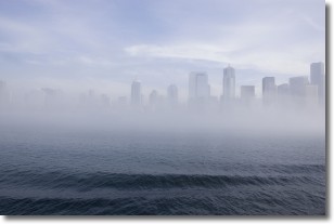
Weather Topic: What is Fog?
Home - Education - Cloud Types - Fog
 Next Topic: Fractus Clouds
Fog is technically a type of stratus cloud, which lies along the
ground and obscures visibility.
It is usually created when humidity in the air condenses into tiny water droplets.
Because of this, some places are more prone to foggy weather, such as regions
close to a body of water.
Fog is similar to mist; both are the appearance of water droplets suspended in
the air, but fog is the term applied to the condition when visibility is less than 1 km.
Next Topic: Fractus Clouds
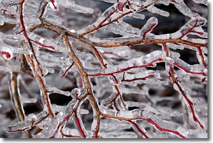
Weather Topic: What is Freezing Rain?
Home - Education - Precipitation - Freezing Rain
 Next Topic: Graupel
Freezing rain is a condition where precipitation which has fallen in the form of
water droplets reaches temperatures which are below freezing and freezes upon
coming into contact
with surface objects. The result of this precipitation is a glaze of ice which
can be damaging to plants and man-made structures. A severe onset of freezing
rain which results in a very thick glaze of ice is known as an ice storm.
Next Topic: Graupel
Current conditions powered by WeatherAPI.com


