Weather Alert in Alaska
Winter Storm Watch issued March 1 at 2:45PM AKST until March 4 at 3:00AM AKST by NWS Juneau AK
AREAS AFFECTED: Glacier Bay; Eastern Chichagof Island; Cape Fairweather to Lisianski Strait; Admiralty Island; City and Borough of Juneau
DESCRIPTION: ...MULTIPLE ROUNDS OF SNOWFALL EXPECTED THROUGH EARLY WEEK... The active weather pattern continues with split flow developing as an incoming front stalls across the central panhandle, with cold strong northerly outflow winds across the northern inner channels and warmer southerly winds across the southern panhandle. Portions of the central and southern panhandle will see moderate to heavy snowfall through Sunday evening as another surge of moisture pushes into the area. A transition to a rain snow mix is expected through Monday morning for the southern panhandle up to Sumner Strait. Main forecast challenge is potential for temperatures to warm up quicker than expected through Sunday night and into Monday morning with the front moving further north, limiting snowfall accumulations. Another system will bring more accumulating snow to the panhandle Monday night into Tuesday night. The track of this follow up feature could lead to significant swings in snow accumulations from Frederick Sound northward to the Icy Strait corridor. * WHAT...Heavy snow possible. Total snow accumulations of 8 to 13 inches possible. * WHERE...Glacier Bay, Eastern Chichagof Island, Cape Fairweather to Lisianski Strait, Admiralty Island and City and Borough of Juneau. * WHEN...From late Monday night through late Tuesday night. * IMPACTS...Travel could be very difficult and is discouraged. The hazardous conditions could impact the morning or evening commute. * ADDITIONAL DETAILS...An arctic boundary over the panhandle is expected to continue to linger around Frederick Sound Monday into Tuesday. An approaching system will bring a fresh influx of moisture and moderate to heavy snow to the central panhandle. A more southerly track of this feature could lead to much lower snow totals for communities north of Angoon.
INSTRUCTION: Monitor the latest forecasts for updates on this situation.
Want more detail? Get the Complete 7 Day and Night Detailed Forecast!
Current U.S. National Radar--Current
The Current National Weather Radar is shown below with a UTC Time (subtract 5 hours from UTC to get Eastern Time).

National Weather Forecast--Current
The Current National Weather Forecast and National Weather Map are shown below.

National Weather Forecast for Tomorrow
Tomorrow National Weather Forecast and Tomorrow National Weather Map are show below.

North America Water Vapor (Moisture)
This map shows recent moisture content over North America. Bright and colored areas show high moisture (ie, clouds); brown indicates very little moisture present; black indicates no moisture.

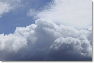
Weather Topic: What are Nimbostratus Clouds?
Home - Education - Cloud Types - Nimbostratus Clouds
 Next Topic: Precipitation
A nimbostratus cloud is similar to a stratus cloud in its formless,
smooth appearance. However, a nimbostratus cloud is darker than a stratus cloud,
because it is thicker.
Unlike a stratus cloud, a nimbostratus cloud typically brings with it the threat
of moderate to heavy precipitation. In some cases, the precipitation may evaporate
before reaching the ground, a phenomenon known as virga.
Next Topic: Precipitation
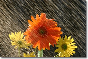
Weather Topic: What is Rain?
Home - Education - Precipitation - Rain
 Next Topic: Shelf Clouds
Precipitation in the form of water droplets is called rain.
Rain generally has a tendency to fall with less intensity over a greater period
of time, and when rainfall is more severe it is usually less sustained.
Rain is the most common form of precipitation and happens with greater frequency
depending on the season and regional influences. Cities have been shown to have
an observable effect on rainfall, due to an effect called the urban heat island.
Compared to upwind, monthly rainfall between twenty and forty miles downwind of
cities is 30% greater.
Next Topic: Shelf Clouds
Current conditions powered by WeatherAPI.com


