Weather Alert in Alaska
Winter Weather Advisory issued March 1 at 2:45PM AKST until March 2 at 6:00AM AKST by NWS Juneau AK
AREAS AFFECTED: Prince of Wales Island; City and Borough of Wrangell
DESCRIPTION: ...MULTIPLE ROUNDS OF SNOWFALL EXPECTED THROUGH EARLY WEEK... The active weather pattern continues with split flow developing as an incoming front stalls across the central panhandle, with cold strong northerly outflow winds across the northern inner channels and warmer southerly winds across the southern panhandle. Portions of the central and southern panhandle will see moderate to heavy snowfall through Sunday evening as another surge of moisture pushes into the area. A transition to a rain snow mix is expected through Monday morning for the southern panhandle up to Sumner Strait. Main forecast challenge is potential for temperatures to warm up quicker than expected through Sunday night and into Monday morning with the front moving further north, limiting snowfall accumulations. Another system will bring more accumulating snow to the panhandle Monday night into Tuesday night. The track of this follow up feature could lead to significant swings in snow accumulations from Frederick Sound northward to the Icy Strait corridor. * WHAT...Snow. Additional snow accumulations of up to 5 inches. * WHERE...Prince of Wales Island and City and Borough of Wrangell. * WHEN...Until 6 AM AKST Monday. * IMPACTS...Travel could be very difficult. The hazardous conditions could impact the morning commute. * ADDITIONAL DETAILS...Highest snowfall totals will remain on the northern side of Prince of Wales Island and upper elevations near Wrangell. Heaviest snowfall rates are expected Sunday afternoon through Sunday night. Snow ratios will decrease through Sunday night as warm air pushes northward with a transition to a mixed precipitation through late Monday morning.
INSTRUCTION: Slow down and use caution while traveling. People are urged to prepare their property before the onset of winter weather. For the latest road conditions, where available, call 5 1 1 or visit 511.alaska.gov.
Want more detail? Get the Complete 7 Day and Night Detailed Forecast!
Current U.S. National Radar--Current
The Current National Weather Radar is shown below with a UTC Time (subtract 5 hours from UTC to get Eastern Time).

National Weather Forecast--Current
The Current National Weather Forecast and National Weather Map are shown below.

National Weather Forecast for Tomorrow
Tomorrow National Weather Forecast and Tomorrow National Weather Map are show below.

North America Water Vapor (Moisture)
This map shows recent moisture content over North America. Bright and colored areas show high moisture (ie, clouds); brown indicates very little moisture present; black indicates no moisture.

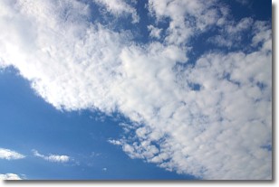
Weather Topic: What are Stratus Clouds?
Home - Education - Cloud Types - Stratus Clouds
 Next Topic: Wall Clouds
Stratus clouds are similar to altostratus clouds, but form at a
lower altitude and are identified by their fog-like appearance, lacking the
distinguishing features of most clouds.
Stratus clouds are wider than most clouds, and their base has a smooth, uniform
look which is lighter in color than a nimbostratus cloud.
The presence of a stratus cloud indicates the possibility of minor precipitation,
such as drizzle, but heavier precipitation does not typically arrive in the form
of a stratus cloud.
Next Topic: Wall Clouds
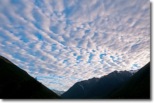
Weather Topic: What are Altocumulus Clouds?
Home - Education - Cloud Types - Altocumulus Clouds
 Next Topic: Altostratus Clouds
Similar to cirrocumulus clouds, altocumulus clouds are
characterized by cloud patches. They are distinguished by larger cloudlets
than cirrocumulus clouds but are still smaller than stratocumulus clouds.
Altocumulus clouds most commonly form in middle altitudes (between 2 and 5 km)
and may resemble, at times, the shape of a flying saucer.
These uncommon formations, called altocumulus lenticularis, are created by uplift
in the atmosphere and are most often seen in close proximity to mountains.
Next Topic: Altostratus Clouds
Current conditions powered by WeatherAPI.com


