Weather Alert in Alaska
Winter Storm Watch issued March 1 at 2:45PM AKST until March 4 at 3:00AM AKST by NWS Juneau AK
AREAS AFFECTED: City and Borough of Sitka; Western Kupreanof and Kuiu Island
DESCRIPTION: ...MULTIPLE ROUNDS OF SNOWFALL EXPECTED THROUGH EARLY WEEK... The active weather pattern continues with split flow developing as an incoming front stalls across the central panhandle, with cold strong northerly outflow winds across the northern inner channels and warmer southerly winds across the southern panhandle. Portions of the central and southern panhandle will see moderate to heavy snowfall through Sunday evening as another surge of moisture pushes into the area. A transition to a rain snow mix is expected through Monday morning for the southern panhandle up to Sumner Strait. Main forecast challenge is potential for temperatures to warm up quicker than expected through Sunday night and into Monday morning with the front moving further north, limiting snowfall accumulations. Another system will bring more accumulating snow to the panhandle Monday night into Tuesday night. The track of this follow up feature could lead to significant swings in snow accumulations from Frederick Sound northward to the Icy Strait corridor. * WHAT...For the Winter Weather Advisory, snow. Additional snow accumulations of 4 to 6 inches. For the Winter Storm Watch, heavy snow possible. Total snow accumulations of 6 to 12 inches possible. Winds could gust as high as 35 mph. * WHERE...City and Borough of Sitka and Western Kupreanof Island and Kuiu Island. * WHEN...For the Winter Weather Advisory, until 9 AM AKST Monday. For the Winter Storm Watch, from late Monday night through late Tuesday night. * IMPACTS...Travel could be very difficult and is discouraged. The hazardous conditions could impact the morning or evening commute. * ADDITIONAL DETAILS...For the winter weather advisory, heaviest snowfall rates are expected through Sunday night. For the winter storm watch, the arctic boundary over the panhandle is expected to continue to linger around Frederick Sound Monday into Tuesday. An approaching system will bring a fresh influx of moisture and moderate to heavy snow, with a quicker transition to a rain snow mix for the outer coast depending upon the track of the low.
INSTRUCTION: Slow down and use caution while traveling. Monitor the latest forecasts for updates on this situation. People are urged to prepare their property before the onset of winter weather. For the latest road conditions, where available, call 5 1 1 or visit 511.alaska.gov.
Want more detail? Get the Complete 7 Day and Night Detailed Forecast!
Current U.S. National Radar--Current
The Current National Weather Radar is shown below with a UTC Time (subtract 5 hours from UTC to get Eastern Time).

National Weather Forecast--Current
The Current National Weather Forecast and National Weather Map are shown below.

National Weather Forecast for Tomorrow
Tomorrow National Weather Forecast and Tomorrow National Weather Map are show below.

North America Water Vapor (Moisture)
This map shows recent moisture content over North America. Bright and colored areas show high moisture (ie, clouds); brown indicates very little moisture present; black indicates no moisture.

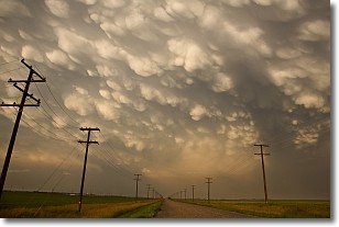
Weather Topic: What are Mammatus Clouds?
Home - Education - Cloud Types - Mammatus Clouds
 Next Topic: Nimbostratus Clouds
A mammatus cloud is a cloud with a unique feature which resembles
a web of pouches hanging along the base of the cloud.
In the United States, mammatus clouds tend to form in the warmer months, commonly
in the Midwest and eastern regions.
While they usually form at the bottom of a cumulonimbis cloud, they can also form
under altostratus, altocumulus, stratocumulus, and cirrus clouds. Mammatus clouds
warn that severe weather is close.
Next Topic: Nimbostratus Clouds
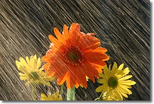
Weather Topic: What is Precipitation?
Home - Education - Precipitation - Precipitation
 Next Topic: Rain
Precipitation can refer to many different forms of water that
may fall from clouds. Precipitation occurs after a cloud has become saturated to
the point where its water particles are more dense than the air below the cloud.
In most cases, precipitation will reach the ground, but it is not uncommon for
precipitation to evaporate before it reaches the earth's surface.
When precipitation evaporates before it contacts the ground it is called Virga.
Graupel, hail, sleet, rain, drizzle, and snow are forms of precipitation, but fog
and mist are not considered precipitation because the water vapor which
constitutes them isn't dense enough to fall to the ground.
Next Topic: Rain
Current conditions powered by WeatherAPI.com


