Weather Alert in Alaska
Winter Storm Warning issued March 1 at 2:45PM AKST until March 2 at 9:00AM AKST by NWS Juneau AK
AREAS AFFECTED: City of Hyder
DESCRIPTION: ...MULTIPLE ROUNDS OF SNOWFALL EXPECTED THROUGH EARLY WEEK... The active weather pattern continues with split flow developing as an incoming front stalls across the central panhandle, with cold strong northerly outflow winds across the northern inner channels and warmer southerly winds across the southern panhandle. Portions of the central and southern panhandle will see moderate to heavy snowfall through Sunday evening as another surge of moisture pushes into the area. A transition to a rain snow mix is expected through Monday morning for the southern panhandle up to Sumner Strait. Main forecast challenge is potential for temperatures to warm up quicker than expected through Sunday night and into Monday morning with the front moving further north, limiting snowfall accumulations. Another system will bring more accumulating snow to the panhandle Monday night into Tuesday night. The track of this follow up feature could lead to significant swings in snow accumulations from Frederick Sound northward to the Icy Strait corridor. * WHAT...Heavy wet snow. Additional snow accumulations of 6 to 9 inches. * WHERE...City of Hyder. * WHEN...Until 9 AM AKST Monday. * IMPACTS...Travel will be very difficult. * ADDITIONAL DETAILS...A transition to a rain snow mix is expected at times Sunday afternoon with a transition to predominately rain by Monday afternoon.
INSTRUCTION: If you must travel, keep an extra flashlight, food, and water with you in case of an emergency. People are urged to prepare their property before the onset of winter weather.
Want more detail? Get the Complete 7 Day and Night Detailed Forecast!
Current U.S. National Radar--Current
The Current National Weather Radar is shown below with a UTC Time (subtract 5 hours from UTC to get Eastern Time).

National Weather Forecast--Current
The Current National Weather Forecast and National Weather Map are shown below.

National Weather Forecast for Tomorrow
Tomorrow National Weather Forecast and Tomorrow National Weather Map are show below.

North America Water Vapor (Moisture)
This map shows recent moisture content over North America. Bright and colored areas show high moisture (ie, clouds); brown indicates very little moisture present; black indicates no moisture.

Weather Topic: What are Cumulus Clouds?
Home - Education - Cloud Types - Cumulus Clouds
 Next Topic: Drizzle
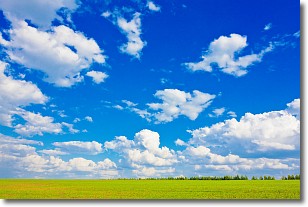
Cumulus clouds are fluffy and textured with rounded tops, and
may have flat bottoms. The border of a cumulus cloud
is clearly defined, and can have the appearance of cotton or cauliflower.
Cumulus clouds form at low altitudes (rarely above 2 km) but can grow very tall,
becoming cumulus congestus and possibly the even taller cumulonimbus clouds.
When cumulus clouds become taller, they have a greater chance of producing precipitation.
Next Topic: Drizzle
Weather Topic: What is Evaporation?
Home - Education - Precipitation - Evaporation
 Next Topic: Fog
Evaporation is the process which returns water from the earth
back to the atmosphere, and is another crucial process in the water cycle.
Evaporation is the transformation of liquid into gas, and it happens because
molecules are excited by the application of energy and turn into vapor.
In order for water to evaporate it has to be on the surface of a body of water.
Next Topic: Fog
Current conditions powered by WeatherAPI.com


