Weather Alert in Alabama
Flood Watch issued August 4 at 12:49AM EDT until August 5 at 8:00PM EDT by NWS Tallahassee FL
AREAS AFFECTED: Coffee; Dale; Henry; Geneva; Houston; North Walton; Central Walton; Holmes; Washington; Jackson; Inland Bay; Calhoun; Inland Gulf; Inland Franklin; Gadsden; Leon; Inland Jefferson; Madison; Inland Wakulla; South Walton; Coastal Bay; Coastal Gulf; Coastal Franklin; Coastal Jefferson; Coastal Wakulla; Northern Liberty; Southern Liberty; Quitman; Clay; Randolph; Calhoun; Terrell; Dougherty; Lee; Worth; Turner; Tift; Ben Hill; Irwin; Early; Miller; Baker; Mitchell; Colquitt; Cook; Berrien; Seminole; Decatur; Grady; Thomas; Brooks; Lowndes; Lanier
DESCRIPTION: * WHAT...Flooding caused by excessive rainfall continues to be possible. * WHERE...Portions of southeast Alabama, including the following areas, Coffee, Dale, Geneva, Henry and Houston, Florida, including the following areas, Calhoun, Central Walton, Coastal Bay, Coastal Franklin, Coastal Gulf, Coastal Jefferson, Coastal Wakulla, Gadsden, Holmes, Inland Bay, Inland Franklin, Inland Gulf, Inland Jefferson, Inland Wakulla, Jackson, Leon, Madison, North Walton, Northern Liberty, South Walton, Southern Liberty and Washington, and Georgia, including the following areas, Baker, Ben Hill, Berrien, Brooks, Calhoun, Clay, Colquitt, Cook, Decatur, Dougherty, Early, Grady, Irwin, Lanier, Lee, Lowndes, Miller, Mitchell, Quitman, Randolph, Seminole, Terrell, Thomas, Tift, Turner and Worth. * WHEN...Through Tuesday evening. * IMPACTS...Excessive runoff may result in flooding of rivers, creeks, streams, and other low-lying and flood-prone locations. Flooding may occur in poor drainage and urban areas. Storm drains and ditches may become clogged with debris. * ADDITIONAL DETAILS... - Periods of heavy rain remain likely through Tuesday afternoon. Training showers and storms are expected to move in from the Gulf as they overspread the Florida Panhandle into portions of southeastern Alabama and southwestern Georgia later today. A similar setup is expected Tuesday. While there is a bit of uncertainty with regards to where the heaviest rain will fall on Tuesday, parts of the area received upwards of 5" to 9" Sunday afternoon and evening, which has caused 1-hr Flash Flood Guidance to drop to around 2". That doesn't even include any of today's rain, which could reduce that further. For this reason, the Flood Watch was extended through Tuesday afternoon. Rainfall rates of 2" to 4" per hour are expected within the more efficient rain producing showers and storms. Additional widespread rainfall through Tuesday is between 1" to 3", but localized areas could see upwards of 8" or more with most CAM guidance suggesting that occurring along the Emerald Coast into the Florida Panhandle. - Http://www.weather.gov/safety/flood
INSTRUCTION: You should monitor later forecasts and be alert for possible Flood Warnings. Those living in areas prone to flooding should be prepared to take action should flooding develop.
Want more detail? Get the Complete 7 Day and Night Detailed Forecast!
Current U.S. National Radar--Current
The Current National Weather Radar is shown below with a UTC Time (subtract 5 hours from UTC to get Eastern Time).

National Weather Forecast--Current
The Current National Weather Forecast and National Weather Map are shown below.

National Weather Forecast for Tomorrow
Tomorrow National Weather Forecast and Tomorrow National Weather Map are show below.

North America Water Vapor (Moisture)
This map shows recent moisture content over North America. Bright and colored areas show high moisture (ie, clouds); brown indicates very little moisture present; black indicates no moisture.

Weather Topic: What is Freezing Rain?
Home - Education - Precipitation - Freezing Rain
 Next Topic: Graupel
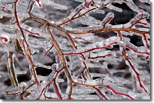
Freezing rain is a condition where precipitation which has fallen in the form of
water droplets reaches temperatures which are below freezing and freezes upon
coming into contact
with surface objects. The result of this precipitation is a glaze of ice which
can be damaging to plants and man-made structures. A severe onset of freezing
rain which results in a very thick glaze of ice is known as an ice storm.
Next Topic: Graupel
Weather Topic: What is Hail?
Home - Education - Precipitation - Hail
 Next Topic: Hole Punch Clouds
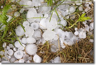
Hail is a form of precipitation which is recognized by large solid balls or
clumps of ice. Hail is created by thunderstorm clouds with strong updrafts of wind.
As the hailstones remain in the updraft, ice is deposited onto them until their
weight becomes heavy enough for them to fall to the earth's surface.
Hail storms can cause significant damage to crops, aircrafts, and man-made structures,
despite the fact that the duration is usually less than ten minutes.
Next Topic: Hole Punch Clouds
Current conditions powered by WeatherAPI.com


