Weather Alert in Florida
Rip Current Statement issued April 4 at 2:10AM EDT until April 5 at 3:00AM EDT by NWS Melbourne FL
AREAS AFFECTED: Coastal Volusia; Coastal Indian River; Coastal St. Lucie; Coastal Martin; Mainland Northern Brevard; Northern Brevard Barrier Islands; Mainland Southern Brevard; Southern Brevard Barrier Islands
DESCRIPTION: * WHAT...Dangerous rip currents. * WHERE...Coastal Volusia, Coastal Brevard, Coastal Indian River, Coastal Saint Lucie, and Coastal Martin counties. * WHEN...Through late tonight. * IMPACTS...Rip currents can sweep even the best swimmers away from shore into deeper water.
INSTRUCTION: Rip currents are powerful channels of water flowing quickly away from shore, which occur most often at low spots or breaks in the sandbar and in the vicinity of structures such as jetties and piers. Heed the advice of lifeguards, beach patrol flags and signs. Entering the surf is strongly discouraged. If caught in a rip current, relax and float. Don't swim against the current. If able, swim in a direction following the shoreline. If unable to escape, face the shore and call or wave for help.
Want more detail? Get the Complete 7 Day and Night Detailed Forecast!
Current U.S. National Radar--Current
The Current National Weather Radar is shown below with a UTC Time (subtract 5 hours from UTC to get Eastern Time).

National Weather Forecast--Current
The Current National Weather Forecast and National Weather Map are shown below.

National Weather Forecast for Tomorrow
Tomorrow National Weather Forecast and Tomorrow National Weather Map are show below.

North America Water Vapor (Moisture)
This map shows recent moisture content over North America. Bright and colored areas show high moisture (ie, clouds); brown indicates very little moisture present; black indicates no moisture.

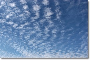
Weather Topic: What are Cirrocumulus Clouds?
Home - Education - Cloud Types - Cirrocumulus Clouds
 Next Topic: Cirrostratus Clouds
Cirrocumulus clouds form at high altitudes (usually around 5 km)
and have distinguishing characteristics displayed in a fine layer of
small cloud patches. These small cloud patches are sometimes referred to as
"cloudlets" in relation to the whole cloud formation.
Cirrocumulus clouds are formed from ice crystals and water droplets. Often, the
water droplets in the cloud freeze into ice crystals and the cloud becomes a
cirrostratus cloud. Because of this common occurrence, cirrocumulus cloud
formations generally pass rapidly.
Next Topic: Cirrostratus Clouds
Weather Topic: What are Cirrus Clouds?
Home - Education - Cloud Types - Cirrus Clouds
 Next Topic: Condensation
Cirrus clouds are high-level clouds that occur above 20,000 feet
and are composed mainly of ice crystals.
They are thin and wispy in appearance.
What do they indicate?
They are often the first sign of an approaching storm.
Next Topic: Condensation
Current conditions powered by WeatherAPI.com


