Weather Alert in Michigan
Air Quality Alert issued July 3 at 11:29AM EDT by NWS Northern Indiana
AREAS AFFECTED: Northern Berrien; Southern Berrien
DESCRIPTION: The Michigan Department of Environment, Great Lakes, and Energy (EGLE) has declared an Air Quality Advisory for Friday July 4, for elevated levels of ozone along the Lake Michigan shoreline. Pollutants within those areas are expected to be in the Unhealthy for Sensitive Groups (USG, Orange AQI) range. The Air Quality Advisory is in effect for the following counties in southwest Michigan... Berrien Ample sunshine, surface temperatures in the 80s and favorable winds will create a conducive environment for Ozone development along the Lake Michigan shoreline on July 4th. It is recommended that, when possible, you avoid strenuous outdoor activities, especially those with respiratory diseases such as asthma. People and businesses are urged to avoid activities which lead to ozone formation. These activities include: * refueling vehicles or topping off when refueling; * using gasoline powered lawn equipment; * using charcoal lighter fluid. Positive activities include: * driving less; * telecommuting; * walking or bike riding; * delaying or combining errands; * using water-based paints. For up-to-date air quality data for Michigan visit the MiAir site: https://air-egle.hub.arcgis.com/ For up-to-date air quality data nationally visit EPA's Air Now site: https://www.airnow.gov/
INSTRUCTION: N/A
Want more detail? Get the Complete 7 Day and Night Detailed Forecast!
Current U.S. National Radar--Current
The Current National Weather Radar is shown below with a UTC Time (subtract 5 hours from UTC to get Eastern Time).

National Weather Forecast--Current
The Current National Weather Forecast and National Weather Map are shown below.

National Weather Forecast for Tomorrow
Tomorrow National Weather Forecast and Tomorrow National Weather Map are show below.

North America Water Vapor (Moisture)
This map shows recent moisture content over North America. Bright and colored areas show high moisture (ie, clouds); brown indicates very little moisture present; black indicates no moisture.

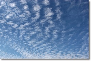
Weather Topic: What are Cirrocumulus Clouds?
Home - Education - Cloud Types - Cirrocumulus Clouds
 Next Topic: Cirrostratus Clouds
Cirrocumulus clouds form at high altitudes (usually around 5 km)
and have distinguishing characteristics displayed in a fine layer of
small cloud patches. These small cloud patches are sometimes referred to as
"cloudlets" in relation to the whole cloud formation.
Cirrocumulus clouds are formed from ice crystals and water droplets. Often, the
water droplets in the cloud freeze into ice crystals and the cloud becomes a
cirrostratus cloud. Because of this common occurrence, cirrocumulus cloud
formations generally pass rapidly.
Next Topic: Cirrostratus Clouds
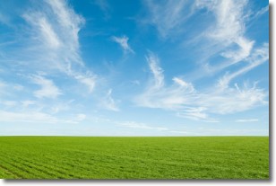
Weather Topic: What are Cirrus Clouds?
Home - Education - Cloud Types - Cirrus Clouds
 Next Topic: Condensation
Cirrus clouds are high-level clouds that occur above 20,000 feet
and are composed mainly of ice crystals.
They are thin and wispy in appearance.
What do they indicate?
They are often the first sign of an approaching storm.
Next Topic: Condensation
Current conditions powered by WeatherAPI.com


