Weather Alert in Montana
Winter Weather Advisory issued February 26 at 1:30PM MST until February 28 at 2:00AM MST by NWS Missoula MT
AREAS AFFECTED: West Glacier Region
DESCRIPTION: ...GLACIER PARK AND HIGHWAY 2 SNOW - FRIDAY INTO SATURDAY... .A back door cold front will help create winter travel conditions in and near Glacier National Park as well as the Highway 2 corridor from West Glacier to Marias Pass from Friday into early Saturday morning. * WHAT...Snow and wind expected. There is a chance of minor to moderate winter weather impacts. Total snow accumulations between 2 and 6 inches along Highway 2 from West Glacier to Marias Pass. Total snow accumulations of up to 10 inches above the pass, with locally higher amounts possible in the higher peaks. Wind gusts up to 65 mph could cause blowing and drifting of snow and decreased visibility to less than one-half mile at times. * WHERE...Glacier National Park, Polebridge, Essex, Highway 83 Bigfork to Swan Lake, Marias Pass, and Bad Rock Canyon. * WHEN...From noon Friday to 2 AM MST Saturday. * IMPACTS...For MINOR winter weather impacts, expect a few inconveniences to normal activities. Use caution while driving. Winter traveling conditions. The hazardous conditions could impact the Friday evening commute, especially over higher passes.
INSTRUCTION: Slow down and use caution while traveling. The latest road conditions for the state you are calling from can be obtained by calling 5 1 1.
Want more detail? Get the Complete 7 Day and Night Detailed Forecast!
Current U.S. National Radar--Current
The Current National Weather Radar is shown below with a UTC Time (subtract 5 hours from UTC to get Eastern Time).

National Weather Forecast--Current
The Current National Weather Forecast and National Weather Map are shown below.

National Weather Forecast for Tomorrow
Tomorrow National Weather Forecast and Tomorrow National Weather Map are show below.

North America Water Vapor (Moisture)
This map shows recent moisture content over North America. Bright and colored areas show high moisture (ie, clouds); brown indicates very little moisture present; black indicates no moisture.

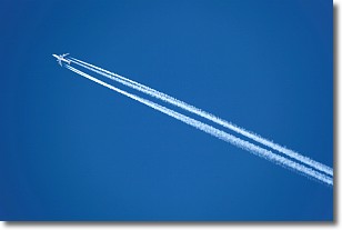
Weather Topic: What are Contrails?
Home - Education - Cloud Types - Contrails
 Next Topic: Cumulonimbus Clouds
A contrail is an artificial cloud, created by the passing of an
aircraft.
Contrails form because water vapor in the exhaust of aircraft engines is suspended
in the air under certain temperatures and humidity conditions. These contrails
are called exhaust contrails.
Another type of contrail can form due to a temporary reduction in air pressure
moving over the plane's surface, causing condensation.
These are called aerodynamic contrails.
When you can see your breath on a cold day, it is also because of condensation.
The reason contrails last longer than the condensation from your breath is
because the water in contrails freezes into ice particles.
Next Topic: Cumulonimbus Clouds
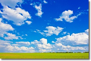
Weather Topic: What are Cumulus Clouds?
Home - Education - Cloud Types - Cumulus Clouds
 Next Topic: Drizzle
Cumulus clouds are fluffy and textured with rounded tops, and
may have flat bottoms. The border of a cumulus cloud
is clearly defined, and can have the appearance of cotton or cauliflower.
Cumulus clouds form at low altitudes (rarely above 2 km) but can grow very tall,
becoming cumulus congestus and possibly the even taller cumulonimbus clouds.
When cumulus clouds become taller, they have a greater chance of producing precipitation.
Next Topic: Drizzle
Current conditions powered by WeatherAPI.com


