Weather Alert in Montana
Winter Weather Advisory issued February 26 at 1:30PM MST until February 28 at 2:00AM MST by NWS Missoula MT
AREAS AFFECTED: West Glacier Region
DESCRIPTION: ...GLACIER PARK AND HIGHWAY 2 SNOW - FRIDAY INTO SATURDAY... .A back door cold front will help create winter travel conditions in and near Glacier National Park as well as the Highway 2 corridor from West Glacier to Marias Pass from Friday into early Saturday morning. * WHAT...Snow and wind expected. There is a chance of minor to moderate winter weather impacts. Total snow accumulations between 2 and 6 inches along Highway 2 from West Glacier to Marias Pass. Total snow accumulations of up to 10 inches above the pass, with locally higher amounts possible in the higher peaks. Wind gusts up to 65 mph could cause blowing and drifting of snow and decreased visibility to less than one-half mile at times. * WHERE...Glacier National Park, Polebridge, Essex, Highway 83 Bigfork to Swan Lake, Marias Pass, and Bad Rock Canyon. * WHEN...From noon Friday to 2 AM MST Saturday. * IMPACTS...For MINOR winter weather impacts, expect a few inconveniences to normal activities. Use caution while driving. Winter traveling conditions. The hazardous conditions could impact the Friday evening commute, especially over higher passes.
INSTRUCTION: Slow down and use caution while traveling. The latest road conditions for the state you are calling from can be obtained by calling 5 1 1.
Want more detail? Get the Complete 7 Day and Night Detailed Forecast!
Current U.S. National Radar--Current
The Current National Weather Radar is shown below with a UTC Time (subtract 5 hours from UTC to get Eastern Time).

National Weather Forecast--Current
The Current National Weather Forecast and National Weather Map are shown below.

National Weather Forecast for Tomorrow
Tomorrow National Weather Forecast and Tomorrow National Weather Map are show below.

North America Water Vapor (Moisture)
This map shows recent moisture content over North America. Bright and colored areas show high moisture (ie, clouds); brown indicates very little moisture present; black indicates no moisture.

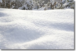
Weather Topic: What is Snow?
Home - Education - Precipitation - Snow
 Next Topic: Stratocumulus Clouds
Snow is precipitation taking the form of ice crystals. Each ice crystal, or snowflake,
has unique characteristics, but all of them grow in a hexagonal structure.
Snowfall can last for sustained periods of time and result in significant buildup
of snow on the ground.
On the earth's surface, snow starts out light and powdery, but as it begins to melt
it tends to become more granular, producing small bits of ice which have the consistency of
sand. After several cycles of melting and freezing, snow can become very dense
and ice-like, commonly known as snow pack.
Next Topic: Stratocumulus Clouds
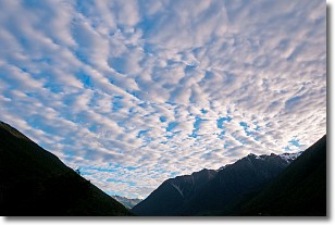
Weather Topic: What are Stratus Clouds?
Home - Education - Cloud Types - Stratus Clouds
 Next Topic: Wall Clouds
Stratus clouds are similar to altostratus clouds, but form at a
lower altitude and are identified by their fog-like appearance, lacking the
distinguishing features of most clouds.
Stratus clouds are wider than most clouds, and their base has a smooth, uniform
look which is lighter in color than a nimbostratus cloud.
The presence of a stratus cloud indicates the possibility of minor precipitation,
such as drizzle, but heavier precipitation does not typically arrive in the form
of a stratus cloud.
Next Topic: Wall Clouds
Current conditions powered by WeatherAPI.com


