Weather Alert in South Dakota
Red Flag Warning issued February 26 at 10:04PM MST until February 27 at 6:00PM MST by NWS Rapid City SD
AREAS AFFECTED: Fall River County Area
DESCRIPTION: ...RED FLAG WARNING IN EFFECT FROM NOON MST/100 PM CST TO 600 PM MST/700 PM CST FRIDAY FOR GUSTY WINDS AND LOW RELATIVE HUMIDITY FOR FIRE WEATHER ZONES 315, 317, 322, 326, 333, 334, AND 335... .Very dry air will affect parts of northeastern Wyoming as well as far southwestern into south-central South Dakota Friday afternoon. Minimum relative humidities will drop to 15 to 20 percent as northwest winds blow at 10 to 25 mph with gusts from 25 to 40 mph, strongest over south-central South Dakota. Antecedent D1 to D2 drought conditions will exacerbate the fire potential. The combination of low humidity values and gusty winds will create critical fire weather conditions on Friday for these areas. The National Weather Service in Rapid City has issued a Red Flag Warning for gusty winds and low relative humidity, which is in effect from noon to 6 PM MST Friday. The Fire Weather Watch is no longer in effect. * AFFECTED AREA...Fire Weather Zone 322 Fall River County Area. * WINDS...Northwest 10 to 20 mph with gusts up to 30 mph. * RELATIVE HUMIDITY...As low as 15 percent. * IMPACTS...The combination of gusty winds and low relative humidity would produce critical fire weather conditions.
INSTRUCTION: A Red Flag Warning means that critical fire weather conditions are either occurring now, or will shortly. A combination of strong winds, low relative humidity, and warm temperatures can contribute to extreme fire behavior.
Want more detail? Get the Complete 7 Day and Night Detailed Forecast!
Current U.S. National Radar--Current
The Current National Weather Radar is shown below with a UTC Time (subtract 5 hours from UTC to get Eastern Time).

National Weather Forecast--Current
The Current National Weather Forecast and National Weather Map are shown below.

National Weather Forecast for Tomorrow
Tomorrow National Weather Forecast and Tomorrow National Weather Map are show below.

North America Water Vapor (Moisture)
This map shows recent moisture content over North America. Bright and colored areas show high moisture (ie, clouds); brown indicates very little moisture present; black indicates no moisture.

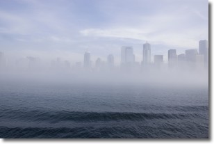
Weather Topic: What is Fog?
Home - Education - Cloud Types - Fog
 Next Topic: Fractus Clouds
Fog is technically a type of stratus cloud, which lies along the
ground and obscures visibility.
It is usually created when humidity in the air condenses into tiny water droplets.
Because of this, some places are more prone to foggy weather, such as regions
close to a body of water.
Fog is similar to mist; both are the appearance of water droplets suspended in
the air, but fog is the term applied to the condition when visibility is less than 1 km.
Next Topic: Fractus Clouds
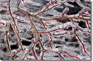
Weather Topic: What is Freezing Rain?
Home - Education - Precipitation - Freezing Rain
 Next Topic: Graupel
Freezing rain is a condition where precipitation which has fallen in the form of
water droplets reaches temperatures which are below freezing and freezes upon
coming into contact
with surface objects. The result of this precipitation is a glaze of ice which
can be damaging to plants and man-made structures. A severe onset of freezing
rain which results in a very thick glaze of ice is known as an ice storm.
Next Topic: Graupel
Current conditions powered by WeatherAPI.com


