Weather Alert in Montana
High Wind Warning issued February 26 at 12:47PM MST until February 27 at 5:00PM MST by NWS Billings MT
AREAS AFFECTED: Northern Stillwater; Golden Valley; Judith Gap; Northern Sweet Grass; Melville Foothills; Southern Wheatland
DESCRIPTION: * WHAT...West winds gusting 60 to 75 mph, strongest near the foothills. * WHERE...Portions of central and south central Montana. * WHEN...Until 5 PM MST Friday. * IMPACTS...Strong crosswinds will make travel difficult along Highway 191 from Big Timber through Judith Gap, and Highway 12 from Harlowton to Lavina. Warm and dry conditions could cause rapid fire spread in wildland grasses. * ADDITIONAL DETAILS...The strongest winds gusts are expected today into Friday morning.
INSTRUCTION: Winds this strong can make driving difficult, especially for high profile vehicles. Use extra caution and consider postponing travel until winds subside, or take an alternate route. Secure loose outdoor items. Use caution with any burning activities.
Want more detail? Get the Complete 7 Day and Night Detailed Forecast!
Current U.S. National Radar--Current
The Current National Weather Radar is shown below with a UTC Time (subtract 5 hours from UTC to get Eastern Time).

National Weather Forecast--Current
The Current National Weather Forecast and National Weather Map are shown below.

National Weather Forecast for Tomorrow
Tomorrow National Weather Forecast and Tomorrow National Weather Map are show below.

North America Water Vapor (Moisture)
This map shows recent moisture content over North America. Bright and colored areas show high moisture (ie, clouds); brown indicates very little moisture present; black indicates no moisture.

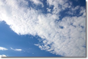
Weather Topic: What are Stratus Clouds?
Home - Education - Cloud Types - Stratus Clouds
 Next Topic: Wall Clouds
Stratus clouds are similar to altostratus clouds, but form at a
lower altitude and are identified by their fog-like appearance, lacking the
distinguishing features of most clouds.
Stratus clouds are wider than most clouds, and their base has a smooth, uniform
look which is lighter in color than a nimbostratus cloud.
The presence of a stratus cloud indicates the possibility of minor precipitation,
such as drizzle, but heavier precipitation does not typically arrive in the form
of a stratus cloud.
Next Topic: Wall Clouds
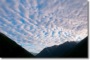
Weather Topic: What are Altocumulus Clouds?
Home - Education - Cloud Types - Altocumulus Clouds
 Next Topic: Altostratus Clouds
Similar to cirrocumulus clouds, altocumulus clouds are
characterized by cloud patches. They are distinguished by larger cloudlets
than cirrocumulus clouds but are still smaller than stratocumulus clouds.
Altocumulus clouds most commonly form in middle altitudes (between 2 and 5 km)
and may resemble, at times, the shape of a flying saucer.
These uncommon formations, called altocumulus lenticularis, are created by uplift
in the atmosphere and are most often seen in close proximity to mountains.
Next Topic: Altostratus Clouds
Current conditions powered by WeatherAPI.com


