Weather Alert in Illinois
Flood Watch issued April 4 at 2:10PM CDT until April 6 at 7:00AM CDT by NWS Lincoln IL
AREAS AFFECTED: Piatt; Champaign; Vermilion; Sangamon; Christian; Macon; Moultrie; Douglas; Coles; Edgar; Shelby; Cumberland; Clark; Effingham; Jasper; Crawford; Clay; Richland; Lawrence
DESCRIPTION: * WHAT...Flooding caused by excessive rainfall continues to be possible. * WHERE...Portions of central, east central, and southeast Illinois, including the following counties, in central Illinois, Christian, Macon, Piatt, Sangamon and Shelby. In east central Illinois, Champaign, Clark, Coles, Cumberland, Douglas, Edgar, Moultrie and Vermilion. In southeast Illinois, Clay, Crawford, Effingham, Jasper, Lawrence and Richland. * WHEN...Through 7 AM Sunday morning. * IMPACTS...Excessive runoff may result in flooding of rivers, creeks, streams, and other low-lying and flood-prone locations. * ADDITIONAL DETAILS... - Multiple rounds of showers and thunderstorms will likely bring an additional 1 to 3 inches of rain through Saturday night, with 3 to 4 inches possible in southeast IL from I-70 southeast. The heaviest rainfall will occur this evening with 1 to 2 inches of rain expected along and southeast of a Taylorville to Decatur to Champaign line. - http://www.weather.gov/safety/flood
INSTRUCTION: You should monitor later forecasts and be alert for possible Flood Warnings. Those living in areas prone to flooding should be prepared to take action should flooding develop.
Want more detail? Get the Complete 7 Day and Night Detailed Forecast!
Current U.S. National Radar--Current
The Current National Weather Radar is shown below with a UTC Time (subtract 5 hours from UTC to get Eastern Time).

National Weather Forecast--Current
The Current National Weather Forecast and National Weather Map are shown below.

National Weather Forecast for Tomorrow
Tomorrow National Weather Forecast and Tomorrow National Weather Map are show below.

North America Water Vapor (Moisture)
This map shows recent moisture content over North America. Bright and colored areas show high moisture (ie, clouds); brown indicates very little moisture present; black indicates no moisture.

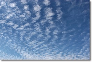
Weather Topic: What are Cirrocumulus Clouds?
Home - Education - Cloud Types - Cirrocumulus Clouds
 Next Topic: Cirrostratus Clouds
Cirrocumulus clouds form at high altitudes (usually around 5 km)
and have distinguishing characteristics displayed in a fine layer of
small cloud patches. These small cloud patches are sometimes referred to as
"cloudlets" in relation to the whole cloud formation.
Cirrocumulus clouds are formed from ice crystals and water droplets. Often, the
water droplets in the cloud freeze into ice crystals and the cloud becomes a
cirrostratus cloud. Because of this common occurrence, cirrocumulus cloud
formations generally pass rapidly.
Next Topic: Cirrostratus Clouds
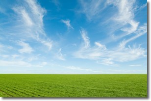
Weather Topic: What are Cirrus Clouds?
Home - Education - Cloud Types - Cirrus Clouds
 Next Topic: Condensation
Cirrus clouds are high-level clouds that occur above 20,000 feet
and are composed mainly of ice crystals.
They are thin and wispy in appearance.
What do they indicate?
They are often the first sign of an approaching storm.
Next Topic: Condensation
Current conditions powered by WeatherAPI.com


