Weather Alert in Arizona
Air Quality Alert issued July 3 at 4:04PM MST by NWS Phoenix AZ
AREAS AFFECTED: Maricopa, AZ
DESCRIPTION: AQAPSR The Arizona Department of Environmental Quality (ADEQ) has issued an Ozone High Pollution Advisory for the Phoenix Metro Area on Monday. This means that forecast weather conditions combined with existing ozone levels are expected to result in local maximum 8-hour ozone concentrations that pose a health risk. Adverse health effects increase as air quality deteriorates. Ozone is an air contaminant which can cause breathing difficulties for children, older adults, as well as persons with respiratory problems. A decrease in physical activity is recommended. You are urged to car pool, telecommute or use mass transit. The use of gasoline-powered equipment should be reduced or done late in the day. For details on this High Pollution Advisory, visit the ADEQ internet site at www.azdeq.gov/forecast/phoenix or call 602-771-2300.
INSTRUCTION: N/A
Want more detail? Get the Complete 7 Day and Night Detailed Forecast!
Current U.S. National Radar--Current
The Current National Weather Radar is shown below with a UTC Time (subtract 5 hours from UTC to get Eastern Time).

National Weather Forecast--Current
The Current National Weather Forecast and National Weather Map are shown below.

National Weather Forecast for Tomorrow
Tomorrow National Weather Forecast and Tomorrow National Weather Map are show below.

North America Water Vapor (Moisture)
This map shows recent moisture content over North America. Bright and colored areas show high moisture (ie, clouds); brown indicates very little moisture present; black indicates no moisture.

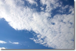
Weather Topic: What are Stratus Clouds?
Home - Education - Cloud Types - Stratus Clouds
 Next Topic: Wall Clouds
Stratus clouds are similar to altostratus clouds, but form at a
lower altitude and are identified by their fog-like appearance, lacking the
distinguishing features of most clouds.
Stratus clouds are wider than most clouds, and their base has a smooth, uniform
look which is lighter in color than a nimbostratus cloud.
The presence of a stratus cloud indicates the possibility of minor precipitation,
such as drizzle, but heavier precipitation does not typically arrive in the form
of a stratus cloud.
Next Topic: Wall Clouds
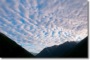
Weather Topic: What are Altocumulus Clouds?
Home - Education - Cloud Types - Altocumulus Clouds
 Next Topic: Altostratus Clouds
Similar to cirrocumulus clouds, altocumulus clouds are
characterized by cloud patches. They are distinguished by larger cloudlets
than cirrocumulus clouds but are still smaller than stratocumulus clouds.
Altocumulus clouds most commonly form in middle altitudes (between 2 and 5 km)
and may resemble, at times, the shape of a flying saucer.
These uncommon formations, called altocumulus lenticularis, are created by uplift
in the atmosphere and are most often seen in close proximity to mountains.
Next Topic: Altostratus Clouds
Current conditions powered by WeatherAPI.com


