Weather Alert in Maryland
Winter Weather Advisory issued March 2 at 6:39AM EST until March 3 at 1:00PM EST by NWS Baltimore MD/Washington DC
AREAS AFFECTED: Eastern Garrett; Western Mineral
DESCRIPTION: * WHAT...Mixed precipitation expected. Total snow accumulations of 1 to 2 inches, with locally up to 3 inches possible. Ice accumulations of one to two tenths of an inch. * WHERE...In Maryland, Eastern Garrett County. In West Virginia, Western Mineral County. * WHEN...From 10 AM this morning to 1 PM EST Tuesday. * IMPACTS...Plan on slippery road conditions. The hazardous conditions could impact the Monday evening and Tuesday morning commutes. * ADDITIONAL DETAILS...A period of snow is expected from late this morning into this afternoon. There may be a break during the late afternoon and early evening before a wintry mix of snow, sleet, and then primarily freezing rain affects the area tonight. Precipitation will gradually change to plain rain by midday Tuesday.
INSTRUCTION: Slow down and use caution while traveling. The latest road conditions for the state you are calling from can be obtained by calling 5 1 1.
Want more detail? Get the Complete 7 Day and Night Detailed Forecast!
Current U.S. National Radar--Current
The Current National Weather Radar is shown below with a UTC Time (subtract 5 hours from UTC to get Eastern Time).

National Weather Forecast--Current
The Current National Weather Forecast and National Weather Map are shown below.

National Weather Forecast for Tomorrow
Tomorrow National Weather Forecast and Tomorrow National Weather Map are show below.

North America Water Vapor (Moisture)
This map shows recent moisture content over North America. Bright and colored areas show high moisture (ie, clouds); brown indicates very little moisture present; black indicates no moisture.

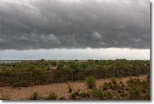
Weather Topic: What are Shelf Clouds?
Home - Education - Cloud Types - Shelf Clouds
 Next Topic: Sleet
A shelf cloud is similar to a wall cloud, but forms at the front
of a storm cloud, instead of at the rear, where wall clouds form.
A shelf cloud is caused by a series of events set into motion by the advancing
storm; first, cool air settles along the ground where precipitation has just fallen.
As the cool air is brought in, the warmer air is displaced, and rises above it,
because it is less dense. When the warmer air reaches the bottom of the storm cloud,
it begins to cool again, and the resulting condensation is a visible shelf cloud.
Next Topic: Sleet
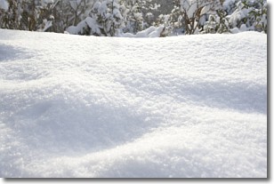
Weather Topic: What is Snow?
Home - Education - Precipitation - Snow
 Next Topic: Stratocumulus Clouds
Snow is precipitation taking the form of ice crystals. Each ice crystal, or snowflake,
has unique characteristics, but all of them grow in a hexagonal structure.
Snowfall can last for sustained periods of time and result in significant buildup
of snow on the ground.
On the earth's surface, snow starts out light and powdery, but as it begins to melt
it tends to become more granular, producing small bits of ice which have the consistency of
sand. After several cycles of melting and freezing, snow can become very dense
and ice-like, commonly known as snow pack.
Next Topic: Stratocumulus Clouds
Current conditions powered by WeatherAPI.com


