Weather Alert in Minnesota
Beach Hazards Statement issued July 3 at 2:02AM CDT until July 3 at 10:00PM CDT by NWS Duluth MN
AREAS AFFECTED: Carlton/South St. Louis; Douglas
DESCRIPTION: * WHAT...Dangerous swimming conditions are expected along the Lake Superior shoreline due to high wave action and strong rip currents. * WHERE...Minnesota Park Point and Wisconsin Point Beaches. * WHEN...From 10 AM CDT this morning through this evening. * IMPACTS...High wave action can make swimming difficult on days such as this. Incoming waves in rapid succession can tire even an experienced swimmer quickly. Rip currents can usher you away from land. To avoid being swept away, swim parallel to the shore to exit a rip current. * ADDITIONAL DETAILS...Wave heights and rip current risk is expected to linger through late this evening.
INSTRUCTION: Remain out of the water to avoid hazardous swimming conditions.
Want more detail? Get the Complete 7 Day and Night Detailed Forecast!
Current U.S. National Radar--Current
The Current National Weather Radar is shown below with a UTC Time (subtract 5 hours from UTC to get Eastern Time).

National Weather Forecast--Current
The Current National Weather Forecast and National Weather Map are shown below.

National Weather Forecast for Tomorrow
Tomorrow National Weather Forecast and Tomorrow National Weather Map are show below.

North America Water Vapor (Moisture)
This map shows recent moisture content over North America. Bright and colored areas show high moisture (ie, clouds); brown indicates very little moisture present; black indicates no moisture.

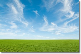
Weather Topic: What are Cirrus Clouds?
Home - Education - Cloud Types - Cirrus Clouds
 Next Topic: Condensation
Cirrus clouds are high-level clouds that occur above 20,000 feet
and are composed mainly of ice crystals.
They are thin and wispy in appearance.
What do they indicate?
They are often the first sign of an approaching storm.
Next Topic: Condensation
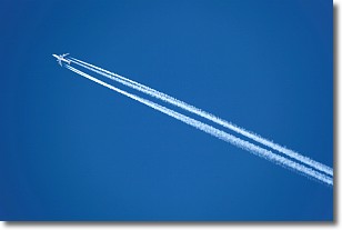
Weather Topic: What are Contrails?
Home - Education - Cloud Types - Contrails
 Next Topic: Cumulonimbus Clouds
A contrail is an artificial cloud, created by the passing of an
aircraft.
Contrails form because water vapor in the exhaust of aircraft engines is suspended
in the air under certain temperatures and humidity conditions. These contrails
are called exhaust contrails.
Another type of contrail can form due to a temporary reduction in air pressure
moving over the plane's surface, causing condensation.
These are called aerodynamic contrails.
When you can see your breath on a cold day, it is also because of condensation.
The reason contrails last longer than the condensation from your breath is
because the water in contrails freezes into ice particles.
Next Topic: Cumulonimbus Clouds
Current conditions powered by WeatherAPI.com


