Weather Alert in Montana
High Wind Watch issued March 5 at 11:28PM MST until March 7 at 11:00PM MST by NWS Great Falls MT
AREAS AFFECTED: Western and Central Chouteau County; Bears Paw Mountains and Southern Blaine; Cascade County below 5000ft; Judith Basin County and Judith Gap; Fergus County below 4500ft
DESCRIPTION: * WHAT...For the first High Wind Watch, west winds 30 to 40 mph, with gusts up to 60 mph possible. For the second High Wind Watch, west winds 30 to 50 mph with gusts up to 70 mph possible. * WHERE...Bears Paw Mountains and Southern Blaine, Cascade County below 5000ft, Fergus County below 4500ft, Judith Basin County and Judith Gap, and Western and Central Chouteau County. * WHEN...For the first High Wind Watch, from Saturday morning through Saturday evening. For the second High Wind Watch, from Sunday morning through Sunday evening. * IMPACTS...High winds may move loose debris, damage property and cause power outages. Travel could be very difficult to dangerous, especially for high profile vehicles. Damaging winds may blow down trees and power lines. * ADDITIONAL DETAILS...The magnitude and duration of the winds on Sunday are expected to be similar to the December 17th event.
INSTRUCTION: Monitor the latest forecasts and warnings for updates. Remember, a High Wind Watch means that there is at least a 50% chance of 40 mph sustained winds or 58 mph wind gusts occurring during the watch period.
Want more detail? Get the Complete 7 Day and Night Detailed Forecast!
Current U.S. National Radar--Current
The Current National Weather Radar is shown below with a UTC Time (subtract 5 hours from UTC to get Eastern Time).

National Weather Forecast--Current
The Current National Weather Forecast and National Weather Map are shown below.

National Weather Forecast for Tomorrow
Tomorrow National Weather Forecast and Tomorrow National Weather Map are show below.

North America Water Vapor (Moisture)
This map shows recent moisture content over North America. Bright and colored areas show high moisture (ie, clouds); brown indicates very little moisture present; black indicates no moisture.

Weather Topic: What is Freezing Rain?
Home - Education - Precipitation - Freezing Rain
 Next Topic: Graupel
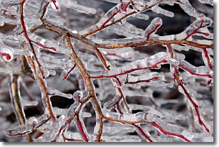
Freezing rain is a condition where precipitation which has fallen in the form of
water droplets reaches temperatures which are below freezing and freezes upon
coming into contact
with surface objects. The result of this precipitation is a glaze of ice which
can be damaging to plants and man-made structures. A severe onset of freezing
rain which results in a very thick glaze of ice is known as an ice storm.
Next Topic: Graupel
Weather Topic: What is Hail?
Home - Education - Precipitation - Hail
 Next Topic: Hole Punch Clouds
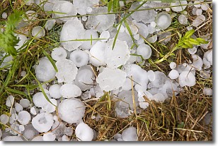
Hail is a form of precipitation which is recognized by large solid balls or
clumps of ice. Hail is created by thunderstorm clouds with strong updrafts of wind.
As the hailstones remain in the updraft, ice is deposited onto them until their
weight becomes heavy enough for them to fall to the earth's surface.
Hail storms can cause significant damage to crops, aircrafts, and man-made structures,
despite the fact that the duration is usually less than ten minutes.
Next Topic: Hole Punch Clouds
Current conditions powered by WeatherAPI.com


