Weather Alert in Montana
High Wind Watch issued March 5 at 11:44PM MST until March 8 at 11:00PM MST by NWS Billings MT
AREAS AFFECTED: Northern Stillwater; Golden Valley; Judith Gap; Northern Sweet Grass; Melville Foothills; Southern Wheatland
DESCRIPTION: * WHAT...West wind gusts up to 70 mph possible. * WHERE...Portions of central and south central Montana. * WHEN...From Saturday afternoon through Sunday evening. * IMPACTS...Strong crosswinds will make travel difficult along Highway 191 from Big Timber through Judith Gap, and Highway 12 from Harlowton to Lavina. * ADDITIONAL DETAILS...Strongest period of winds will be Sunday.
INSTRUCTION: Winds this strong can make driving difficult, especially for high profile vehicles. Use extra caution and consider postponing travel until winds subside, or take an alternate route. Secure loose outdoor items.
Want more detail? Get the Complete 7 Day and Night Detailed Forecast!
Current U.S. National Radar--Current
The Current National Weather Radar is shown below with a UTC Time (subtract 5 hours from UTC to get Eastern Time).

National Weather Forecast--Current
The Current National Weather Forecast and National Weather Map are shown below.

National Weather Forecast for Tomorrow
Tomorrow National Weather Forecast and Tomorrow National Weather Map are show below.

North America Water Vapor (Moisture)
This map shows recent moisture content over North America. Bright and colored areas show high moisture (ie, clouds); brown indicates very little moisture present; black indicates no moisture.

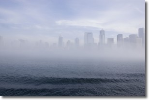
Weather Topic: What is Fog?
Home - Education - Cloud Types - Fog
 Next Topic: Fractus Clouds
Fog is technically a type of stratus cloud, which lies along the
ground and obscures visibility.
It is usually created when humidity in the air condenses into tiny water droplets.
Because of this, some places are more prone to foggy weather, such as regions
close to a body of water.
Fog is similar to mist; both are the appearance of water droplets suspended in
the air, but fog is the term applied to the condition when visibility is less than 1 km.
Next Topic: Fractus Clouds
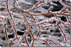
Weather Topic: What is Freezing Rain?
Home - Education - Precipitation - Freezing Rain
 Next Topic: Graupel
Freezing rain is a condition where precipitation which has fallen in the form of
water droplets reaches temperatures which are below freezing and freezes upon
coming into contact
with surface objects. The result of this precipitation is a glaze of ice which
can be damaging to plants and man-made structures. A severe onset of freezing
rain which results in a very thick glaze of ice is known as an ice storm.
Next Topic: Graupel
Current conditions powered by WeatherAPI.com


