Weather Alert in Georgia
Flood Warning issued February 27 at 1:27AM EST until February 27 at 11:00AM EST by NWS Peachtree City GA
AREAS AFFECTED: DeKalb, GA; Fulton, GA
DESCRIPTION: ...The National Weather Service in Peachtree City GA has issued a Flood Warning for the following rivers in Georgia... North Fork Peachtree Creek at Buford Hwy Atlanta affecting Fulton and DeKalb Counties. * WHAT...Minor flooding is occurring. * WHERE...North Fork Peachtree Creek at Buford Hwy Atlanta. * WHEN...From early this morning to this morning. * IMPACTS...At 14.0 feet, Minor flooding continues along the creek upstream and downstream from the gage on Buford Highway or Georgia Highway 13. Portions of the backyards of residential homes on Victory Drive...Dunwoody Place and Converse Drive will be flooded with around one foot of water. This height combined with the flow on South Fork Peachtree Creek will likely produce flooding further downstream on Peachtree Creek in Fulton County. * ADDITIONAL DETAILS... - At 1:15 AM EST Friday the stage was 13.2 feet. - Recent Activity...The maximum river stage in the 24 hours ending at 1:15 AM EST Friday was 13.3 feet. - Forecast...The river is expected to rise to a crest of 13.7 feet early this morning. - Flood stage is 13.0 feet. - Flood History...This crest compares to a previous crest of 13.8 feet on 03/06/2024. - http://www.weather.gov/safety/flood
INSTRUCTION: Be especially cautious at night when it is harder to recognize the dangers of flooding. Additional information is available at weather.gov/atlanta.
Want more detail? Get the Complete 7 Day and Night Detailed Forecast!
Current U.S. National Radar--Current
The Current National Weather Radar is shown below with a UTC Time (subtract 5 hours from UTC to get Eastern Time).

National Weather Forecast--Current
The Current National Weather Forecast and National Weather Map are shown below.

National Weather Forecast for Tomorrow
Tomorrow National Weather Forecast and Tomorrow National Weather Map are show below.

North America Water Vapor (Moisture)
This map shows recent moisture content over North America. Bright and colored areas show high moisture (ie, clouds); brown indicates very little moisture present; black indicates no moisture.

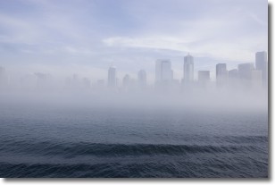
Weather Topic: What is Fog?
Home - Education - Cloud Types - Fog
 Next Topic: Fractus Clouds
Fog is technically a type of stratus cloud, which lies along the
ground and obscures visibility.
It is usually created when humidity in the air condenses into tiny water droplets.
Because of this, some places are more prone to foggy weather, such as regions
close to a body of water.
Fog is similar to mist; both are the appearance of water droplets suspended in
the air, but fog is the term applied to the condition when visibility is less than 1 km.
Next Topic: Fractus Clouds
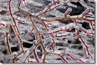
Weather Topic: What is Freezing Rain?
Home - Education - Precipitation - Freezing Rain
 Next Topic: Graupel
Freezing rain is a condition where precipitation which has fallen in the form of
water droplets reaches temperatures which are below freezing and freezes upon
coming into contact
with surface objects. The result of this precipitation is a glaze of ice which
can be damaging to plants and man-made structures. A severe onset of freezing
rain which results in a very thick glaze of ice is known as an ice storm.
Next Topic: Graupel
Current conditions powered by WeatherAPI.com


