Weather Alert in Georgia
Flood Warning issued February 27 at 1:27AM EST until February 27 at 11:00AM EST by NWS Peachtree City GA
AREAS AFFECTED: DeKalb, GA; Fulton, GA
DESCRIPTION: ...The National Weather Service in Peachtree City GA has issued a Flood Warning for the following rivers in Georgia... North Fork Peachtree Creek at Buford Hwy Atlanta affecting Fulton and DeKalb Counties. * WHAT...Minor flooding is occurring. * WHERE...North Fork Peachtree Creek at Buford Hwy Atlanta. * WHEN...From early this morning to this morning. * IMPACTS...At 14.0 feet, Minor flooding continues along the creek upstream and downstream from the gage on Buford Highway or Georgia Highway 13. Portions of the backyards of residential homes on Victory Drive...Dunwoody Place and Converse Drive will be flooded with around one foot of water. This height combined with the flow on South Fork Peachtree Creek will likely produce flooding further downstream on Peachtree Creek in Fulton County. * ADDITIONAL DETAILS... - At 1:15 AM EST Friday the stage was 13.2 feet. - Recent Activity...The maximum river stage in the 24 hours ending at 1:15 AM EST Friday was 13.3 feet. - Forecast...The river is expected to rise to a crest of 13.7 feet early this morning. - Flood stage is 13.0 feet. - Flood History...This crest compares to a previous crest of 13.8 feet on 03/06/2024. - http://www.weather.gov/safety/flood
INSTRUCTION: Be especially cautious at night when it is harder to recognize the dangers of flooding. Additional information is available at weather.gov/atlanta.
Want more detail? Get the Complete 7 Day and Night Detailed Forecast!
Current U.S. National Radar--Current
The Current National Weather Radar is shown below with a UTC Time (subtract 5 hours from UTC to get Eastern Time).

National Weather Forecast--Current
The Current National Weather Forecast and National Weather Map are shown below.

National Weather Forecast for Tomorrow
Tomorrow National Weather Forecast and Tomorrow National Weather Map are show below.

North America Water Vapor (Moisture)
This map shows recent moisture content over North America. Bright and colored areas show high moisture (ie, clouds); brown indicates very little moisture present; black indicates no moisture.

Weather Topic: What are Altostratus Clouds?
Home - Education - Cloud Types - Altostratus Clouds
 Next Topic: Cirrocumulus Clouds
Altostratus clouds form at mid to high-level altitudes
(between 2 and 7 km) and are created by a warm, stable air mass which causes
water vapor
to condense as it rise through the atmosphere. Usually altostratus clouds are
featureless sheets characterized by a uniform color.
In some cases, wind punching through the cloud formation may give it a waved
appearance, called altostratus undulatus. Altostratus clouds
are commonly seen with other cloud formations accompanying them.
Next Topic: Cirrocumulus Clouds
Weather Topic: What are Cirrostratus Clouds?
Home - Education - Cloud Types - Cirrostratus Clouds
 Next Topic: Cirrus Clouds
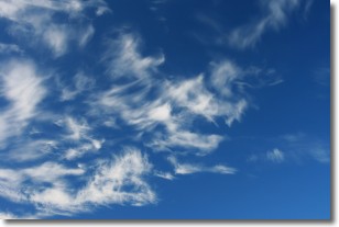
Cirrostratus clouds are high, thin clouds that form above
20,000 feet and are made mostly of ice crystals. They sometimes look like giant
feathers, horse tails, or curls of hair in the sky.
These clouds are pushed by the jet stream and can move at high speeds reaching
100 mph.
What do they indicate?
They indicate that a precipitation is likely within 24 hours.
Next Topic: Cirrus Clouds
Current conditions powered by WeatherAPI.com


