Weather Alert in Ohio
Flood Warning issued March 4 at 5:54AM EST until March 4 at 1:30PM EST by NWS Charleston WV
AREAS AFFECTED: Athens, OH; Gallia, OH; Jackson, OH; Meigs, OH; Vinton, OH; Washington, OH; Jackson, WV; Mason, WV; Pleasants, WV; Wirt, WV; Wood, WV
DESCRIPTION: * WHAT...Flooding caused by excessive rainfall continues. * WHERE...Portions of southeast Ohio, including the following counties, Athens, Gallia, Jackson, Meigs, Vinton and Washington and West Virginia, including the following counties, Jackson, Mason, Pleasants, Wirt and Wood. * WHEN...Until 130 PM EST Wednesday. * IMPACTS...Flooding of rivers, creeks, streams, and other low-lying and flood-prone locations is imminent or occurring. * ADDITIONAL DETAILS... - At 541 AM EST, Earlier heavy rain has lessened this morning, but additional rounds of moderate to heavy rain are likely later this morning. Between 1 and 2 inches of rain have fallen and flooding is already occurring within the warned area. Portions of Stillwell Road are flooded. Additionally, the Shade River near Chester is in action stage and approaching minor flood stage. At 14 feet, low lying areas adjacent to the river flood. Little Tygart Creek at Mineral Wells is also in action stage and approaching minor flood stage. At 10 to 11 feet, Irene Lane and low spots on Woodbridge Golf Course will begin to flood. Upper portions of Raccoon Creek is likely flooding low spots adjacenent the creek. - Additional rainfall amounts up to 0.5 inches are possible in the warned area this morning. Additional rain is likely late morning into the afternoon. - Some locations that will experience flooding include... Parkersburg, Athens, Belpre, Jackson, Wellston, Pomeroy, Mcarthur, Albany, Elizabeth, Racine, Coolville, Rutland, Forked Run State Park, Lake Hope State Park, Vienna, New Haven, Mason, Tuppers Plains, Washington and Lubeck. - http://www.weather.gov/safety/flood
INSTRUCTION: Turn around, don't drown when encountering flooded roads. Most flood deaths occur in vehicles. Report flooding to the National Weather Service by calling toll free, 800 401 9535, when you can do so safely.
Want more detail? Get the Complete 7 Day and Night Detailed Forecast!
Current U.S. National Radar--Current
The Current National Weather Radar is shown below with a UTC Time (subtract 5 hours from UTC to get Eastern Time).

National Weather Forecast--Current
The Current National Weather Forecast and National Weather Map are shown below.

National Weather Forecast for Tomorrow
Tomorrow National Weather Forecast and Tomorrow National Weather Map are show below.

North America Water Vapor (Moisture)
This map shows recent moisture content over North America. Bright and colored areas show high moisture (ie, clouds); brown indicates very little moisture present; black indicates no moisture.

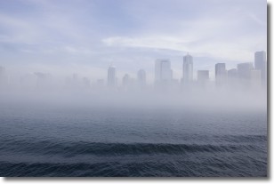
Weather Topic: What is Fog?
Home - Education - Cloud Types - Fog
 Next Topic: Fractus Clouds
Fog is technically a type of stratus cloud, which lies along the
ground and obscures visibility.
It is usually created when humidity in the air condenses into tiny water droplets.
Because of this, some places are more prone to foggy weather, such as regions
close to a body of water.
Fog is similar to mist; both are the appearance of water droplets suspended in
the air, but fog is the term applied to the condition when visibility is less than 1 km.
Next Topic: Fractus Clouds
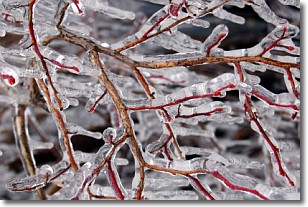
Weather Topic: What is Freezing Rain?
Home - Education - Precipitation - Freezing Rain
 Next Topic: Graupel
Freezing rain is a condition where precipitation which has fallen in the form of
water droplets reaches temperatures which are below freezing and freezes upon
coming into contact
with surface objects. The result of this precipitation is a glaze of ice which
can be damaging to plants and man-made structures. A severe onset of freezing
rain which results in a very thick glaze of ice is known as an ice storm.
Next Topic: Graupel
Current conditions powered by WeatherAPI.com


