Weather Alert in West Virginia
Winter Storm Warning issued March 2 at 12:49AM EST until March 3 at 10:00AM EST by NWS Charleston WV
AREAS AFFECTED: Northwest Pocahontas; Southeast Randolph
DESCRIPTION: * WHAT...Heavy mixed precipitation expected. Total snow accumulations between 1 and 3 inches and ice accumulations up to three tenths of an inch. Locally higher amounts of ice accumulations could be possible. * WHERE...Northwest Pocahontas and Southeast Randolph Counties. * WHEN...From 7 AM this morning to 10 AM EST Tuesday. * IMPACTS...Power outages and tree damage are likely due to the ice. Travel could be nearly impossible this evening into Tuesday morning. The hazardous conditions could impact the morning and evening commutes as well as the Tuesday morning commute. * ADDITIONAL DETAILS...This event will start as all snow with a bulk of the snow accumulations falling this morning into the early afternoon. Freezing rain is then expected to start mixing in by the afternoon and will continue into the evening. This mix is expected to become mostly freezing rain tonight into Tuesday morning. This time period is where a bulk of the ice accretions will occur resulting in the impacts listed.
INSTRUCTION: If you must travel, keep an extra flashlight, food, and water in your vehicle in case of an emergency. The latest road conditions for the state you are calling from can be obtained by calling 5 1 1 or by accessing the online traffic and roadway portal for your state. Additional information can be found at https://www.weather.gov/rlx as well as on our X and Facebook pages.
Want more detail? Get the Complete 7 Day and Night Detailed Forecast!
Current U.S. National Radar--Current
The Current National Weather Radar is shown below with a UTC Time (subtract 5 hours from UTC to get Eastern Time).

National Weather Forecast--Current
The Current National Weather Forecast and National Weather Map are shown below.

National Weather Forecast for Tomorrow
Tomorrow National Weather Forecast and Tomorrow National Weather Map are show below.

North America Water Vapor (Moisture)
This map shows recent moisture content over North America. Bright and colored areas show high moisture (ie, clouds); brown indicates very little moisture present; black indicates no moisture.

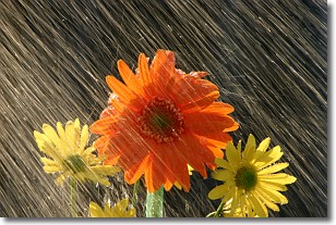
Weather Topic: What is Precipitation?
Home - Education - Precipitation - Precipitation
 Next Topic: Rain
Precipitation can refer to many different forms of water that
may fall from clouds. Precipitation occurs after a cloud has become saturated to
the point where its water particles are more dense than the air below the cloud.
In most cases, precipitation will reach the ground, but it is not uncommon for
precipitation to evaporate before it reaches the earth's surface.
When precipitation evaporates before it contacts the ground it is called Virga.
Graupel, hail, sleet, rain, drizzle, and snow are forms of precipitation, but fog
and mist are not considered precipitation because the water vapor which
constitutes them isn't dense enough to fall to the ground.
Next Topic: Rain
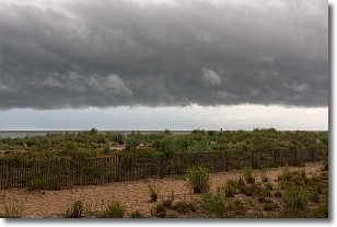
Weather Topic: What are Shelf Clouds?
Home - Education - Cloud Types - Shelf Clouds
 Next Topic: Sleet
A shelf cloud is similar to a wall cloud, but forms at the front
of a storm cloud, instead of at the rear, where wall clouds form.
A shelf cloud is caused by a series of events set into motion by the advancing
storm; first, cool air settles along the ground where precipitation has just fallen.
As the cool air is brought in, the warmer air is displaced, and rises above it,
because it is less dense. When the warmer air reaches the bottom of the storm cloud,
it begins to cool again, and the resulting condensation is a visible shelf cloud.
Next Topic: Sleet
Current conditions powered by WeatherAPI.com


