Weather Alert in Georgia
Flood Warning issued February 26 at 6:28PM EST until February 27 at 2:00AM EST by NWS Peachtree City GA
AREAS AFFECTED: DeKalb, GA; Fulton, GA
DESCRIPTION: ...The National Weather Service in Peachtree City GA has issued a Flood Warning for the following rivers in Georgia... North Fork Peachtree Creek at Buford Hwy Atlanta affecting Fulton and DeKalb Counties. * WHAT...Minor flooding is forecast. * WHERE...North Fork Peachtree Creek at Buford Hwy Atlanta. * WHEN...Until late tonight. * IMPACTS...At 13 feet, Flood stage is reached. Minor flooding of the natural flood plain begins upstream and downstream from the gage on Buford Highway or Georgia Highway 13. This includes low portions of the backyards of residential homes on Victory Drive...Dunwoody Place and Converse Drive. This height combined with the flow on South Fork Peachtree Creek may also produce flooding further downstream on Peachtree Creek in Fulton County. * ADDITIONAL DETAILS... - At 6:15 PM EST Thursday the stage was 12.6 feet and rising. - Forecast...The river is expected to rise above flood stage to near 13.5 feet. It will then fall below flood stage this evening. Additional rises are possible thereafter. - Flood stage is 13 feet. - http://www.weather.gov/safety/flood
INSTRUCTION: Turn around, don't drown when encountering flooded roads. Most flood deaths occur in vehicles. Additional information is available at weather.gov/atlanta.
Want more detail? Get the Complete 7 Day and Night Detailed Forecast!
Current U.S. National Radar--Current
The Current National Weather Radar is shown below with a UTC Time (subtract 5 hours from UTC to get Eastern Time).

National Weather Forecast--Current
The Current National Weather Forecast and National Weather Map are shown below.

National Weather Forecast for Tomorrow
Tomorrow National Weather Forecast and Tomorrow National Weather Map are show below.

North America Water Vapor (Moisture)
This map shows recent moisture content over North America. Bright and colored areas show high moisture (ie, clouds); brown indicates very little moisture present; black indicates no moisture.

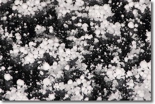
Weather Topic: What is Graupel?
Home - Education - Precipitation - Graupel
 Next Topic: Hail
Graupel is a form of precipitation that is created by atmospheric conditions
which cause supercooled water droplets to contact snow crystals and freeze to
their surface.
Sometimes known as soft hail or snow pellets, graupel is delicate and easily
destroyed by touch. Whereas hail usually falls during severe weather, graupel
doesn't require such conditions to form, and can form in mild precipitation
similar to situations which produce snowfall.
Next Topic: Hail
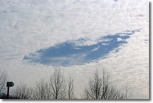
Weather Topic: What are Hole Punch Clouds?
Home - Education - Cloud Types - Hole Punch Clouds
 Next Topic: Mammatus Clouds
A hole punch cloud is an unusual occurrence when a disk-shaped
hole appears in a cirrostratus, cirrocumulus, or altocumulus cloud.
When part of the cloud forms ice crystals, water droplets in the surrounding area
of the cloud evaporate. The effect of this process produces a large elliptical
gap in the cloud. The hole punch cloud formation is rare, but it is not specific
to any geographic area.
Other names which have been used to describe this phenomena include fallstreak hole,
skypunch, and cloud hole.
Next Topic: Mammatus Clouds
Current conditions powered by WeatherAPI.com


