Weather Alert in Illinois
Air Quality Alert issued July 3 at 11:10AM CDT by NWS Chicago IL
AREAS AFFECTED: McHenry; Lake; Kane; DuPage; Kendall; Grundy; Northern Cook; Central Cook; Southern Cook; Northern Will; Southern Will; Eastern Will
DESCRIPTION: The Illinois Environmental Protection Agency has determined that an Air Pollution Action Day will be declared for the greater Chicago Metropolitan Area and is IN EFFECT THROUGH FRIDAY NIGHT. An Air Pollution Action Day is declared when weather conditions are such that widespread ozone and or particulate levels are expected to be at or above the Unhealthy for Sensitive Groups category of the Air Quality Index for multiple days. Ozone is expected to be the primary pollutant of concern, but fireworks emissions may also contribute to higher AQI readings for both PM2.5 and Ozone at times. Active children and adults, especially people with pulmonary or respiratory disease such as asthma, should limit prolonged outdoor activity. Area residents are urged to reduce pollution levels. Air quality forecasts, current air quality, and tips on how you can reduce your emissions can be found at www.airnow.gov. Media contact...Illinois EPA.
INSTRUCTION: N/A
Want more detail? Get the Complete 7 Day and Night Detailed Forecast!
Current U.S. National Radar--Current
The Current National Weather Radar is shown below with a UTC Time (subtract 5 hours from UTC to get Eastern Time).

National Weather Forecast--Current
The Current National Weather Forecast and National Weather Map are shown below.

National Weather Forecast for Tomorrow
Tomorrow National Weather Forecast and Tomorrow National Weather Map are show below.

North America Water Vapor (Moisture)
This map shows recent moisture content over North America. Bright and colored areas show high moisture (ie, clouds); brown indicates very little moisture present; black indicates no moisture.

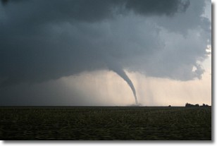
Weather Topic: What are Wall Clouds?
Home - Education - Cloud Types - Wall Clouds
 Next Topic: Altocumulus Clouds
A wall cloud forms underneath the base of a cumulonimbus cloud,
and can be a hotbed for deadly tornadoes.
Wall clouds are formed by air flowing into the cumulonimbus clouds, which can
result in the wall cloud descending from the base of the cumulonimbus cloud, or
rising fractus clouds which join to the base of the storm cloud as the wall cloud
takes shape.
Wall clouds can be very large, and in the Northern Hemisphere they generally
form at the southern edge of cumulonimbus clouds.
Next Topic: Altocumulus Clouds
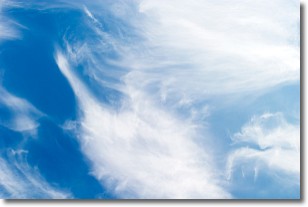
Weather Topic: What are Altostratus Clouds?
Home - Education - Cloud Types - Altostratus Clouds
 Next Topic: Cirrocumulus Clouds
Altostratus clouds form at mid to high-level altitudes
(between 2 and 7 km) and are created by a warm, stable air mass which causes
water vapor
to condense as it rise through the atmosphere. Usually altostratus clouds are
featureless sheets characterized by a uniform color.
In some cases, wind punching through the cloud formation may give it a waved
appearance, called altostratus undulatus. Altostratus clouds
are commonly seen with other cloud formations accompanying them.
Next Topic: Cirrocumulus Clouds
Current conditions powered by WeatherAPI.com


