Weather Alert in Indiana
Flood Warning issued March 6 at 9:14PM EST until March 15 at 6:30PM EDT by NWS Indianapolis IN
AREAS AFFECTED: Daviess, IN; Dubois, IN; Martin, IN; Pike, IN
DESCRIPTION: ...The Flood Warning continues for the following rivers in Indiana... East Fork White River near Rivervale, at Columbus, at Seymour, and near Bedford. Sugar Creek near Edinburgh. Driftwood River near Edinburgh. ...The Flood Warning is extended for the following rivers in Indiana... East Fork White River at Williams and at Shoals. Flatrock River near Columbus. Big Blue River at Shelbyville. .Total rainfall amounts of 3 to over 5 inches of rain across much of central and southern Indiana is bringing widespread moderate flooding across the East Fork White and lower White basins and their tributaries. Additional rainfall over the weekend and next week could lengthen the amount of time area rivers remain in flood or bring additional rises next week. * WHAT...Moderate flooding is forecast. * WHERE...East Fork White River at Shoals. * WHEN...From Sunday morning to Sunday, March 15. * IMPACTS...At 26.0 feet, High water affects low residential areas on left bank at Shoals. Some evacuations or moving of mobile homes is necessary. Local roads flood more extensively. Rural residents move livestock and equipment to high ground. SR 550 floods on right bank and also between Trinity and Dover Hill. * ADDITIONAL DETAILS... - At 8:30 PM EST Friday the stage was 17.4 feet. - Forecast...The river is expected to rise above flood stage Sunday morning to a crest of 26.3 feet early Wednesday morning. It will then fall below flood stage Sunday, March 15. - Flood stage is 20.0 feet. - http://www.weather.gov/safety/flood
INSTRUCTION: Caution is urged when walking near riverbanks. Flooding is occurring or is imminent. Most flood related deaths occur in automobiles. Do not attempt to cross water covered bridges, dips, or low water crossings. Never try to cross a flowing stream, even a small one, on foot. To escape rising water find another route over higher ground. Additional information is available at www.weather.gov/ind. The next statement should be issued Saturday afternoon by around 200 PM EST.
Want more detail? Get the Complete 7 Day and Night Detailed Forecast!
Current U.S. National Radar--Current
The Current National Weather Radar is shown below with a UTC Time (subtract 5 hours from UTC to get Eastern Time).

National Weather Forecast--Current
The Current National Weather Forecast and National Weather Map are shown below.

National Weather Forecast for Tomorrow
Tomorrow National Weather Forecast and Tomorrow National Weather Map are show below.

North America Water Vapor (Moisture)
This map shows recent moisture content over North America. Bright and colored areas show high moisture (ie, clouds); brown indicates very little moisture present; black indicates no moisture.

Weather Topic: What is Drizzle?
Home - Education - Precipitation - Drizzle
 Next Topic: Evaporation
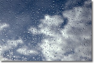
Drizzle is precipitation in the form of water droplets which are
smaller than raindrops.
Drizzle is characterized by fine, gently falling droplets and typically does not
impact human habitation in a negative way. The exception to this is freezing drizzle,
a condition where drizzle freezes immediately upon reaching earth's surface.
Freezing drizzle is still less dangerous than freezing rain, but can
potentially result in hazardous road conditions.
Next Topic: Evaporation
Weather Topic: What is Fog?
Home - Education - Cloud Types - Fog
 Next Topic: Fractus Clouds
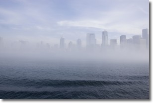
Fog is technically a type of stratus cloud, which lies along the
ground and obscures visibility.
It is usually created when humidity in the air condenses into tiny water droplets.
Because of this, some places are more prone to foggy weather, such as regions
close to a body of water.
Fog is similar to mist; both are the appearance of water droplets suspended in
the air, but fog is the term applied to the condition when visibility is less than 1 km.
Next Topic: Fractus Clouds
Current conditions powered by WeatherAPI.com


