Weather Alert in Texas
Flood Warning issued July 3 at 1:57PM CDT until July 5 at 11:30PM CDT by NWS Midland/Odessa TX
AREAS AFFECTED: Presidio, TX
DESCRIPTION: ...The National Weather Service in Midland/Odessa TX has issued a Flood Warning for the following rivers in Texas... Rio Grande below Rio Grande below Rio Conchos near Presidio, Texas affecting Presidio County. For the Rio Grande...including Rio Grande above Rio Conchos near Presidio, Texas, Rio Grande at Presidio Vehicle Bridge, Rio Grande below Rio Conchos near Presidio, Texas, Rio Grande near Castolon, Texas, Rio Grande at Johnson Ranch near Castolon, Texas, Rio Grande at Rio Grande Village, BBNP, Texas, Rio Grande near Dryden, Texas, Terlingua Creek near Terlingua, Texas...Major flooding is forecast. Additional information is available at www.weather.gov. The next statement will be issued late tonight at 400 AM CDT. * WHAT...Minor flooding is occurring and minor flooding is forecast. * WHERE...Rio Grande below Rio Grande below Rio Conchos near Presidio, Texas. * WHEN...From this morning to late Saturday evening. * IMPACTS...At 9.0 feet (2.7 meters), the river reaches minor flood stage, and low lying areas begin to flood. At 11.0 feet (3.4 meters), minor flooding continues along the river. Irrigation pumps may need to be removed. No threats to residences or other structures are known to occur. At 13.0 feet (4.0 meters), the river reaches moderate flood stage. Farmland near the river will be inundated. Water may begin flooding low lying areas of FM 170. * ADDITIONAL DETAILS... - At 1:15 PM CDT Thursday the stage was 10.9 feet (3.3 meters). - Bankfull stage is 8.0 feet (2.4 meters). - Recent Activity...The maximum river stage in the 24 hours ending at 1:15 PM CDT Thursday was 11.3 feet (3.4 meters). - Forecast...The river is expected to rise to a crest of 11.2 feet (3.4 meters) late this afternoon. It will then fall below flood stage late Saturday morning. - Flood stage is 9.0 feet (2.7 meters). - Flood History...This crest compares to a previous crest of 11.1 feet (3.4 meters) on 09/02/2024. - http://www.weather.gov/safety/flood
INSTRUCTION: N/A
Want more detail? Get the Complete 7 Day and Night Detailed Forecast!
Current U.S. National Radar--Current
The Current National Weather Radar is shown below with a UTC Time (subtract 5 hours from UTC to get Eastern Time).

National Weather Forecast--Current
The Current National Weather Forecast and National Weather Map are shown below.

National Weather Forecast for Tomorrow
Tomorrow National Weather Forecast and Tomorrow National Weather Map are show below.

North America Water Vapor (Moisture)
This map shows recent moisture content over North America. Bright and colored areas show high moisture (ie, clouds); brown indicates very little moisture present; black indicates no moisture.

Weather Topic: What are Cumulonimbus Clouds?
Home - Education - Cloud Types - Cumulonimbus Clouds
 Next Topic: Cumulus Clouds
The final form taken by a growing cumulus cloud is the
cumulonimbus cloud, which is very tall and dense.
The tower of a cumulonimbus cloud can soar 23 km into the atmosphere, although
most commonly they stop growing at an altitude of 6 km.
Even small cumulonimbus clouds appear very large in comparison to other cloud types.
They can signal the approach of stormy weather, such as thunderstorms or blizzards.
Next Topic: Cumulus Clouds
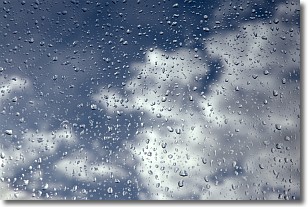
Weather Topic: What is Drizzle?
Home - Education - Precipitation - Drizzle
 Next Topic: Evaporation
Drizzle is precipitation in the form of water droplets which are
smaller than raindrops.
Drizzle is characterized by fine, gently falling droplets and typically does not
impact human habitation in a negative way. The exception to this is freezing drizzle,
a condition where drizzle freezes immediately upon reaching earth's surface.
Freezing drizzle is still less dangerous than freezing rain, but can
potentially result in hazardous road conditions.
Next Topic: Evaporation
Current conditions powered by WeatherAPI.com


